Oklahoma and Texas Hail Guaranteed Today but Tornado Window Is Narrow as Supercells Race to Merge Before Storms Can Sustain Rotation
OKLAHOMA CITY, Oklahoma — Saturday’s severe weather setup across Oklahoma and north Texas is coming into sharper focus, and the picture has two very different sides to it. Very large hail is essentially locked in — forecasters describe it as a 100% certainty with today’s supercells. The tornado threat, however, faces several potential fail modes that could limit significant tornado production to a brief early window before storms cluster and lose their individual rotation.
The sounding data valid Saturday evening near the Oklahoma-Texas border tells a story of extraordinary instability but a compromised wind profile that introduces real uncertainty about how long discrete supercells can hold together.
What the Sounding Is Showing
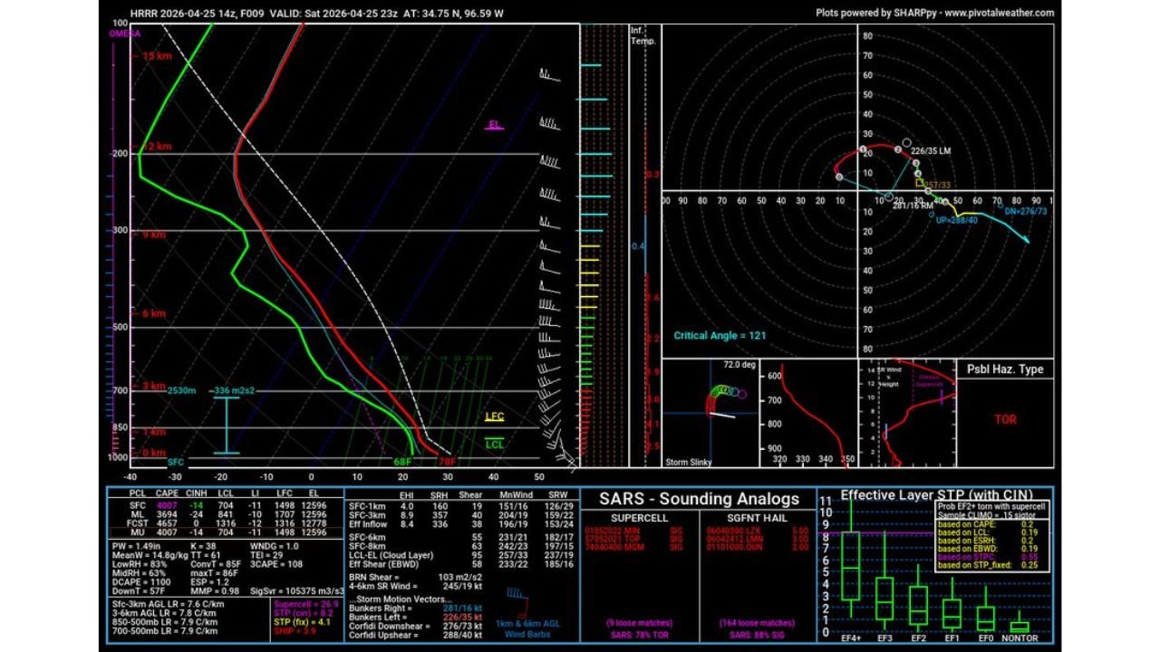
The atmospheric profile for Saturday near 34.75°N, 96.59°W — roughly the southeastern Oklahoma and northeast Texas border zone — shows some impressive numbers alongside some concerning ones.
On the favorable side, mixed-layer CAPE reaches 3,694 J/kg with surface CAPE at 3002 J/kg, representing enormous storm fuel. Storm Relative Helicity sits at -336 m²s² and the effective shear measures 245 knots at the 4-6km layer. The STP value is 4.1 and the sounding analog classification returns TOR as the possible hazard type. SARS analogues show 78% tornadic and 88% significant, suggesting this profile has historically been associated with significant tornado events.
On the concerning side, the critical angle comes in at 121 degrees, which is higher than the near-ideal 90-100 degree range seen in the most efficient tornado environments. The LCL height is 2,530 meters, which is quite high. Higher LCL heights mean the cloud base sits further above the surface, making it harder for rotation to reach the ground and produce a visible, surface-based tornado. The MMP value of 0.98 and the hodograph shape show characteristics that could favor outflow-dominant storm behavior once cells start interacting.
The Three Fail Modes Forecasters Are Watching
Three specific atmospheric problems could limit the tornado threat today, and all three are present in the current data.
The first is the lack of strong low to mid-level winds. Good low-level wind shear is what gives storms the rotational energy they need near the surface where tornadoes form. When that shear is weaker than ideal, storms can still rotate aloft but struggle to bring that rotation down to the ground in a sustained way.
The second is the saturated environment. When the atmosphere is already holding near its maximum moisture capacity, thunderstorms tend to produce more widespread convection rather than discrete, organized supercells. Widespread convection means storms compete with each other, interfere with each other’s inflow, and generally produce less efficient tornado environments than a single isolated supercell with clear access to warm moist air on all sides.
The third is crosswise vorticity in the low levels. Vorticity in the atmosphere spins air like a horizontal tube rolling along the ground. When that spin is oriented crosswise to storm motion rather than streamwise, it is much less efficiently ingested into the storm updraft and converted into the vertical rotation that tornadoes require. Today’s hodograph shape suggests some crosswise component in the low-level vorticity field.
The Narrow Tornado Window and Why It Matters
The HRRR model shows the scenario playing out as follows. Supercells fire early in the afternoon while the atmosphere is still relatively uncongested. During this initial period, while storms remain non-outflow-dominant and discrete, the tornado threat is real. Any significant tornadoes today will almost certainly occur during this early supercell phase.
As the afternoon progresses, individual storm cells will merge into a cluster or convective complex. Once that happens, the organized rotation of individual supercells gets disrupted, cold outflow pools spread across the surface and undercut storm inflow, and the tornado threat drops dramatically. The primary hazard then shifts to large hail and damaging straight-line winds from the cluster as a whole.
This means anyone in the threat zone who is waiting for conditions to worsen before paying attention may miss the entire tornado window. If tornadoes happen today, they happen early. The hail threat extends throughout the afternoon and into the evening regardless of storm mode.
Hail Is the Guaranteed Story Today
While the tornado situation carries uncertainty, very large hail is not conditional today — it is coming. The atmospheric profile supports hailstone growth to significant sizes in the supercell updrafts regardless of whether those storms produce tornadoes. The SARS analogues show 164 matches for significant hail versus 9 for supercell in the tornado category, reflecting that this environment is more consistently associated with large hail production than tornado production in historical cases.
The HRRR radar simulation shows the most intense storm cores concentrated over the Oklahoma-Texas border region near Wichita Falls, Sherman, and into southeastern Oklahoma. Reflectivity values in the deep red range across this cluster indicate cores capable of producing the very large hail that has been forecast all week for this region.
What People in This Zone Should Do Right Now
The narrow tornado window means there is no time to wait and watch how things develop. If you are in southeastern Oklahoma, northeast Texas, or along the Red River corridor, your shelter plan needs to be in place before early afternoon storms fire. The window between initiation and cluster merger could be as short as one to two hours.
Vehicles should be under cover now. The hail threat is not conditional and the strongest cores today could produce stones well above 2 inches in diameter based on the instability values in the sounding.
Watch radar carefully through the early afternoon. The moment supercells begin firing, treat every storm as a potential tornado producer for the duration of the discrete phase. Once storms merge into a cluster, shift your attention to the wind and hail threat from the organized convective system tracking east.
CabarrusWeekly.com will track today’s supercell development across Oklahoma and Texas and provide live updates as storms fire and hail reports come in through the afternoon.