Unexpected Rain Band Sweeps Across the Northeast Saturday Morning Catching Forecast Models Off Guard as Radar Shows Widespread Precipitation From Pennsylvania Through New York and New England
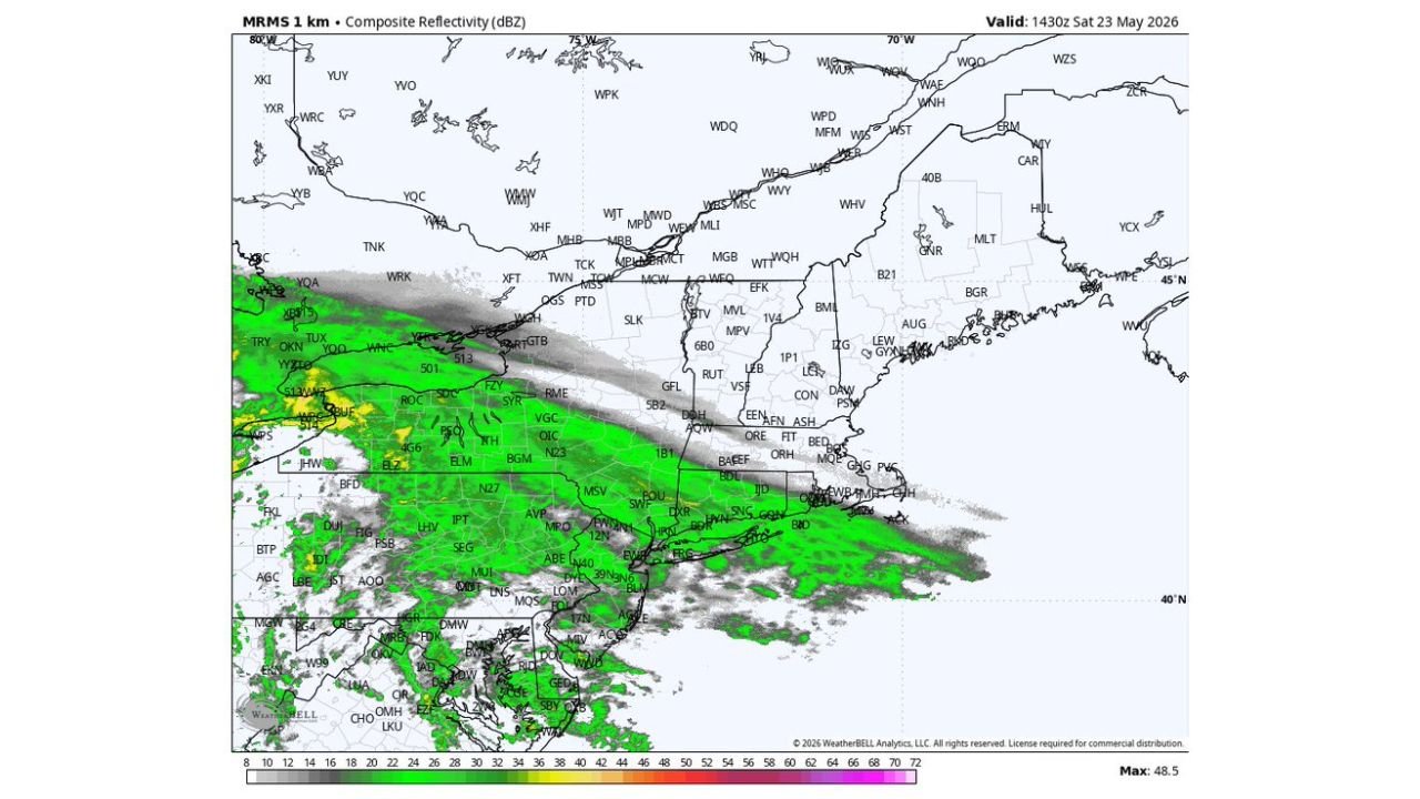
NORTHEASTERN UNITED STATES — An unexpected and widespread rain band is sweeping across the Northeast on Saturday morning, May 23, 2026, showing up clearly on radar valid at 1430Z and catching AI-based forecast models off guard with coverage and intensity that was not well anticipated. The radar is showing a broad area of moderate to heavy rainfall stretching from Pennsylvania through New York, New England, and the broader Northeast corridor.
What Radar Is Showing Right Now
The composite reflectivity radar valid at 1430Z Saturday is painting a significant and organized precipitation band across the Northeast, with:
- Green to yellow reflectivity values ranging up to 48.5 dBZ indicating moderate to locally heavy rainfall
- A broad southwest to northeast oriented rain band draped across the region
- Coverage extending from the mid-Atlantic northward through New York and into New England
- Gray areas of lighter precipitation indicating widespread overcast and drizzle conditions ahead of the heavier rain
The Forecast Models Got This One Wrong
The commentary accompanying this radar image points directly to a forecasting failure by AI-based prediction tools that did not accurately anticipate the extent and intensity of this morning’s precipitation band across the Northeast. This is a timely reminder of a fundamental truth in meteorology: no forecast tool, regardless of how advanced, is infallible. Real-time radar observation will always be the definitive source for what is actually happening in the atmosphere at any given moment.
Why Forecast Busts Happen
Even the most sophisticated forecasting systems can miss events due to:
- Small-scale atmospheric features that fall below the resolution of forecast grids
- Rapidly evolving surface boundaries that shift storm development timing and location
- Moisture interactions that amplify precipitation coverage beyond what models predict
- Feedback loops between clouds and surface heating that alter convective initiation
When a forecast bust occurs, meteorologists pivot immediately to real-time radar and observational data to provide the most accurate and current information possible to the public.
What Northeast Residents Should Know This Morning
Anyone across Pennsylvania, New York, New Jersey, Connecticut, Massachusetts, and surrounding states should expect wet and rainy conditions continuing through Saturday morning as this rain band moves through. Outdoor plans across the Northeast should account for the ongoing precipitation that AI models did not fully capture in advance.
Stay with CabarrusWeekly.com for live radar-based updates across the Northeast through Saturday.