Louisiana and Mississippi Face Brief Tornado Potential and 60 MPH Damaging Winds Saturday May 23 as Afternoon Storm Threat Continues to Grow
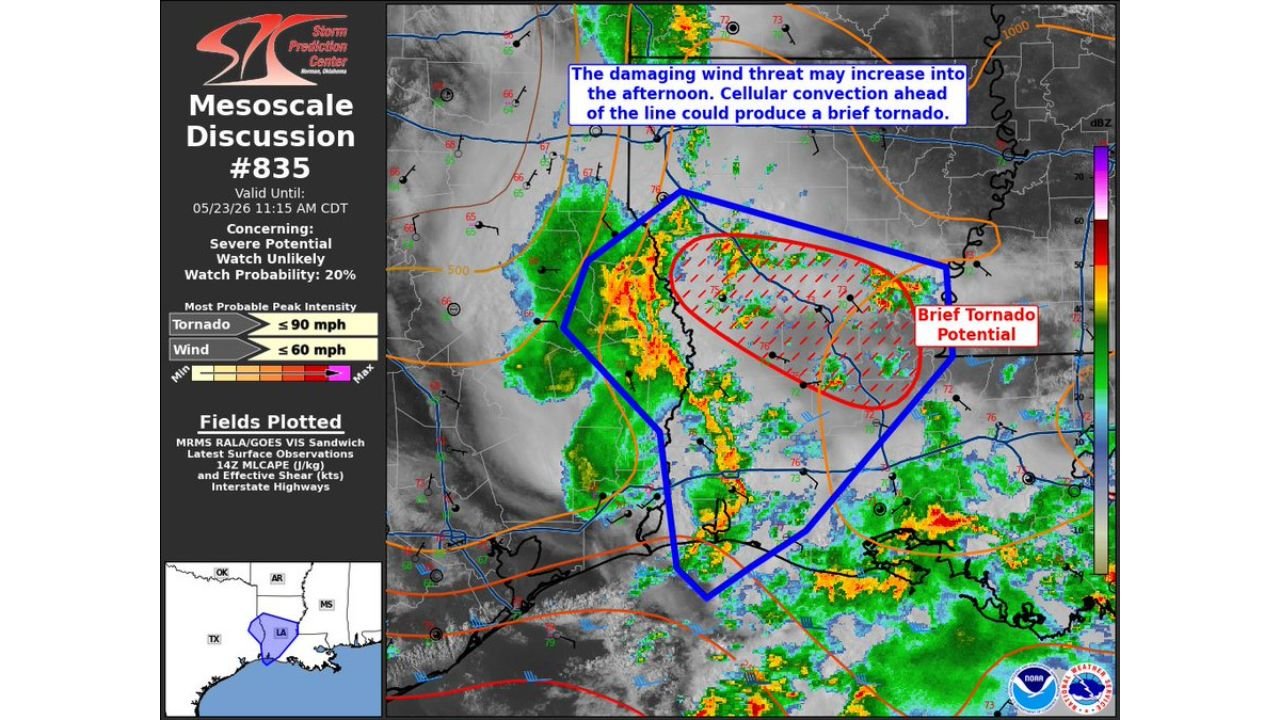
LOUISIANA AND MISSISSIPPI — The Storm Prediction Center has issued Mesoscale Discussion Number 835 covering portions of Louisiana and Mississippi, valid until 11:15 AM CDT on Saturday, May 23, 2026. The discussion identifies a brief tornado potential zone within the broader severe weather corridor, along with a damaging wind threat that is expected to increase into the afternoon hours. A 20 percent watch probability accompanies this discussion, though a watch is currently considered unlikely.
What SPC Is Specifically Warning About
Two distinct threats are outlined in this mesoscale discussion:
- Cellular convection developing ahead of the main storm line carries the potential to produce a brief tornado in the highlighted red zone
- The overall damaging wind threat across the broader blue outlined area is forecast to increase as the day progresses into the afternoon
Peak Intensity Values for This Event
| Threat | Most Probable Peak Intensity |
|---|---|
| Tornado | Up to 90 mph |
| Damaging winds | Up to 60 mph |
Two Overlapping Threat Zones
The discussion highlights two separate but overlapping geographic zones:
Broader blue zone: Covers a wide area across Louisiana and Mississippi, capturing the primary damaging wind threat from the advancing storm line.
Hatched red zone: A tighter area specifically flagged for brief tornado potential from discrete cellular convection developing ahead of the main line of storms.
Watch Probability Remains Low But Non-Zero
The 20 percent watch probability indicates that while a Severe Thunderstorm Watch or Tornado Watch is not currently anticipated, conditions could evolve to warrant one if the storm system intensifies beyond current expectations. Residents in the affected areas should monitor for any watch issuance through the morning and afternoon hours.
The Afternoon Brings Greater Concern
Forecasters are clear that the damaging wind threat will grow as the afternoon arrives. What begins as an organized but limited morning threat has the potential to increase in coverage and intensity as peak heating and instability develop through the midday and afternoon hours across Louisiana and Mississippi.
Stay with CabarrusWeekly.com for live mesoscale discussion and severe weather updates across Louisiana and Mississippi through Saturday afternoon.