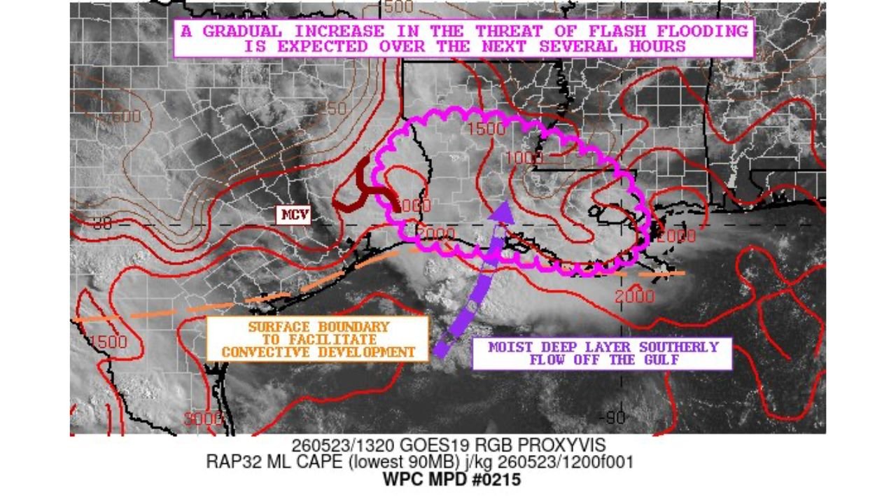
Flash Flooding Threat Gradually Increasing Over the Next Several Hours Across Far Eastern Texas, Central and Southern Louisiana, and Southwest Mississippi Saturday May 23
EASTERN TEXAS, LOUISIANA AND MISSISSIPPI — The Weather Prediction Center has issued a precipitation discussion warning that a gradual increase in the flash flooding threat is expected over the next several hours across far eastern Texas, central and southern Louisiana, and far southwest Mississippi on Saturday, May 23, 2026. The threat is being driven by a combination of a surface boundary facilitating convective development and a moist deep layer southerly flow pushing in off the Gulf of Mexico.
What Is Driving the Growing Flash Flood Threat
Three key atmospheric ingredients are combining to increase the flash flood risk across this region through the morning and afternoon hours:
- A surface boundary positioned across the area is acting as a focus for storm initiation and heavy rainfall development
- Moist deep layer southerly flow off the Gulf is pumping extraordinary amounts of atmospheric moisture into the region, fueling efficient and heavy rainfall-producing storm cells
- A Mesoscale Convective Vortex is also noted on the analysis, adding another layer of forcing that can organize and sustain heavy rainfall over the same areas for extended periods
The Threat Is Gradual but Growing
The word gradual in this discussion is important. Flash flooding is not expected to be immediate, but the threat window is actively expanding as moisture continues to surge northward from the Gulf and storms organize along the surface boundary. Communities across the affected zone should not wait until flooding is occurring to take precautions.
Areas Facing the Growing Flood Threat
The highlighted discussion zone covers:
- Far eastern Texas including the Beaumont and Port Arthur corridor
- Central and southern Louisiana including the Alexandria, Baton Rouge, Lafayette, and Lake Charles areas
- Far southwest Mississippi
Act Before Flooding Arrives
With the flash flood threat on a gradual but confirmed increasing trajectory, residents across far eastern Texas, central and southern Louisiana, and southwest Mississippi should avoid low-lying areas, stay away from drainage channels and bayous, and never attempt to drive through flooded roadways as conditions deteriorate through the day.
Turn Around, Don’t Drown.
Stay with CabarrusWeekly.com for live flash flood updates across eastern Texas, Louisiana, and Mississippi through Saturday.