Oklahoma City, Tulsa, Wichita and Dallas in High-End Severe Weather Zone as Overnight Storm Risk Expands Across Oklahoma, Kansas and North Texas
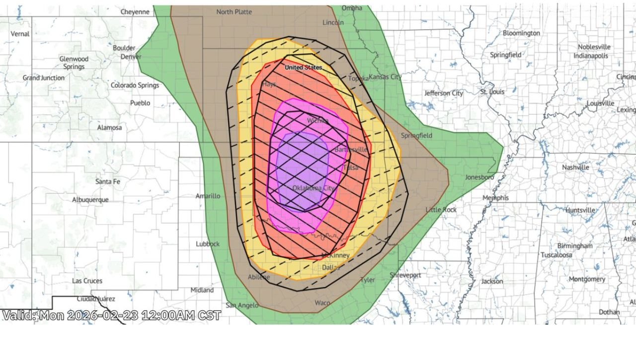
OKLAHOMA — A significant severe weather setup is taking shape across the Southern Plains, with the highest impact zone centered on Oklahoma City, Tulsa, Wichita and extending south toward Dallas, according to the latest outlook valid late Monday night into early Tuesday.
The mapped risk area shows a concentrated core of higher-end severe potential across central and northeastern Oklahoma, with surrounding elevated threat levels stretching into southern Kansas and North Texas.
Highest Risk Centered Over Oklahoma City and Tulsa
The most intense risk shading is positioned directly over Oklahoma City and Tulsa, indicating the strongest potential for organized severe thunderstorms in these areas.
This central corridor extends north toward Wichita, Kansas, and south toward Dallas, Texas, placing multiple metro areas within a zone of enhanced severe weather potential.
Communities inside this core zone could experience strong thunderstorms capable of damaging winds, large hail and potentially tornado development, especially if storms become organized overnight.
Elevated Risk Extends Into Kansas and North Texas
Beyond the highest concentration zone, the broader risk area stretches:
- North toward Hays and central Kansas
- East toward the Arkansas border
- South into portions of North Texas, including Dallas
Cities such as Bartlesville, Topeka and areas near the Kansas City region are included within outer risk bands, indicating at least some potential for severe storm development.
The southern extension places Abilene and areas west of Dallas near the edge of the stronger storm environment.
Surrounding States Under Broader Storm Watch
A wider green-shaded region indicates general thunderstorm potential extending west toward Amarillo, Lubbock and San Angelo, and eastward toward parts of Arkansas including Little Rock and Jonesboro.
While the most significant severe parameters appear focused on Oklahoma and southern Kansas, instability and wind dynamics could allow storms to intensify quickly within the broader region.
The outlook suggests a multi-state impact zone spanning Oklahoma, Kansas and Texas, with peripheral effects possible in Arkansas.
Timing: Late Monday Night Into Early Tuesday
The outlook is valid as of 12:00 AM CST Monday, highlighting overnight storm development potential.
Overnight severe weather events can be particularly hazardous due to reduced visibility and sleeping populations. Residents within the highlighted corridor should ensure weather alerts are enabled and safety plans are in place before storms develop.
Storm mode and intensity will depend on how quickly storms organize and whether discrete cells form ahead of any larger complex.
What This Means for North Carolina
At this time, the severe weather threat remains confined to the Southern Plains and does not directly impact North Carolina.
However, Cabarrus Weekly will continue monitoring national weather patterns that could influence downstream systems later in the week.
Residents in Oklahoma City, Tulsa, Wichita, Dallas and surrounding communities should remain weather-aware through the overnight period.
If you are located in Oklahoma, Kansas or North Texas and experience strong storms tonight, share your conditions with us at CabarrusWeekly.com to help keep others informed.