Week 2 Severe Signal Intensifies Across Texas, Oklahoma and Kansas as March 5–11 Window Shows Elevated Supercell Potential
UNITED STATES — Long-range severe weather guidance is beginning to align on a potentially active stretch between March 5 and March 11, with the Southern and Central Plains emerging as the primary corridor for elevated supercell potential.
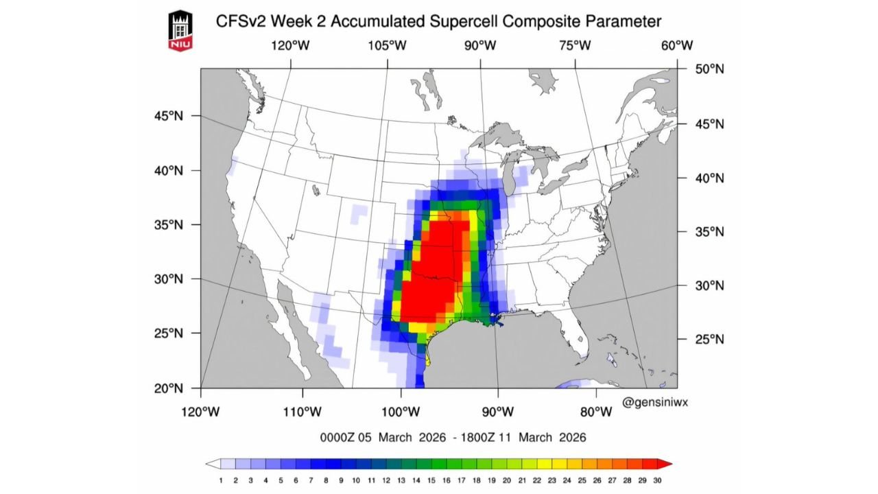
New CFSv2 Week 2 Supercell Composite Parameter projections show a concentrated zone of heightened severe-weather signals extending from central and south Texas northward through Oklahoma and into Kansas, with the strongest values centered over the heart of the Southern Plains.
Core Signal Centered Over the Southern Plains
The most intense composite values — depicted in red on the guidance — are focused across:
- Central and north Texas
- Oklahoma
- Southern and central Kansas
This zone suggests repeated favorable ingredients for organized severe thunderstorms, including instability, wind shear, and lift overlapping over multiple days during the March 5–11 window.
The signal extends southward toward the Texas Gulf Coast and north into portions of Nebraska and Missouri, though the highest concentration remains anchored across Texas and Oklahoma.
Multi-Day Active Period Possible
Unlike a single-day spike, the accumulated composite parameter indicates potential for multiple rounds of favorable severe-weather environments during the period.
An active western trough pattern combined with Gulf moisture return would support:
- Repeated low-pressure systems ejecting eastward
- Strengthening low-level flow from the Gulf of Mexico
- Increasing vertical wind shear across the Plains
If these elements phase properly, several days within the window could feature severe thunderstorm development.
Moisture and Instability Corridor
The composite parameter highlights a corridor running from the Texas Gulf Coast inland through Dallas–Fort Worth, Oklahoma City, and Wichita.
This corridor historically represents a favored early-season severe zone when moisture surges northward and upper-level support arrives from the Southwest.
While early March setups can sometimes struggle with quality moisture depth, the broad signal across multiple states suggests a pattern supportive of sustained Gulf return.
Expansion Toward the Mid-Mississippi Valley
The outer edge of elevated values reaches into parts of:
- Arkansas
- Missouri
- Southern Illinois
This implies that if storm systems track farther east, severe potential could expand beyond the Plains into the Mid-South and lower Midwest during the period.
What It Means for Now
It is important to emphasize that Week 2 guidance identifies pattern-level potential, not specific outbreak days. Exact timing, storm mode, and severity magnitude will depend on how individual shortwaves evolve.
However, the alignment of heightened composite values from Texas through Oklahoma into Kansas signals that early March may mark the beginning of a more active severe weather season across the Plains.
Residents across the Southern Plains should monitor forecast updates as higher-resolution models begin resolving individual systems in the coming days.
Stay with CabarrusWeekly.com for continued coverage as the March 5–11 period approaches and details come into sharper focus.