North Carolina, South Carolina, Georgia and Tennessee Brace for 5–8+ Inches of Rain as Early March Storm Pattern Raises Flash Flood Risk
NORTH CAROLINA — A powerful and unusually wet early-March storm pattern is taking shape across the Southeast, with multiple forecast models signaling the potential for 5 to 8 or more inches of rainfall across parts of North Carolina, South Carolina, Georgia, Tennessee and surrounding states over the next 1 to 2 weeks.
Ensemble guidance from the EPS (European model), GEFS (American model), and the National Blend of Models is showing remarkable agreement on a heavy rainfall corridor stretching from the Deep South through the Tennessee Valley and into the Carolinas.
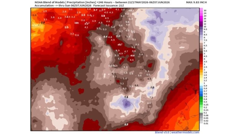
Widespread 5–8+ Inch Totals Showing Up in Multiple Models
Latest mean QPF (quantitative precipitation forecast) output highlights:
• Northern Georgia: 6–8+ inches
• Upstate South Carolina: 5–8 inches
• Western and central North Carolina: 4–7+ inches
• Eastern Tennessee and Kentucky: 5–8 inches
• Northern Alabama and Mississippi: 5–7 inches
Some localized pockets in the Appalachians and foothills are even hinting at higher totals depending on storm track and training bands.
For Cabarrus County and the Charlotte metro region, current projections place the area in a zone potentially receiving 4 to 6+ inches during the first half of March.
Why Confidence Is Growing
It’s not just one model showing heavy rain — it’s several independent systems:
• EPS ensemble mean
• GEFS ensemble mean
• National Blend of Models
• Deterministic guidance supporting the same storm corridor
When multiple ensembles align on a high-QPF signal this far out, it strengthens confidence that a sustained wet pattern is developing.
The storm track appears to favor repeated Gulf moisture surges lifting northeastward into the Southeast and Mid-Atlantic.
Drought Relief — But At A Cost
After several months of below-average rainfall across the Southeast, this pattern could significantly dent drought conditions.
However, forecasters are cautioning that:
• Flash flooding could become a concern
• River flooding may develop if totals verify
• Saturated soils could increase runoff quickly
With rainfall potentially arriving in multiple waves, cumulative totals will matter more than any single storm.
Timing: First 1–2 Weeks of March
The heaviest rainfall signals are concentrated between:
• March 1 – March 14
Several storm systems may track through during this window rather than one single major event.
This increases the potential for:
• Repeated rounds of moderate to heavy rain
• Training thunderstorms
• Prolonged wet ground conditions
What Cabarrus County Should Watch
For residents in Cabarrus County and across central North Carolina:
• Monitor local flood-prone areas
• Prepare for extended wet conditions
• Stay alert for potential flood advisories
While beneficial for water supply and soil moisture, the intensity and duration of this signal raise legitimate flooding concerns if model projections hold.
Bottom Line
The signal for heavy rainfall across North Carolina, South Carolina, Georgia, Tennessee and neighboring states during the first half of March is unusually strong for this range.
If current projections verify, the Southeast could see one of its wetter early-March stretches in recent memory — bringing meaningful drought relief but also increasing the risk for flooding.
Cabarrus Weekly will continue tracking updated rainfall totals and local flood risk as new data becomes available.