Massive Severe Weather Threat Spans Texas to Pennsylvania: Over 90 Million From Houston and New Orleans to Nashville, Atlanta, Cincinnati and Pittsburgh in Today’s Risk Zone
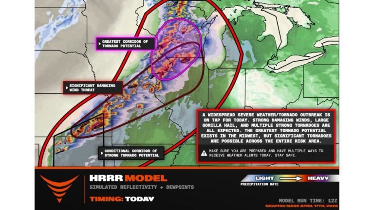
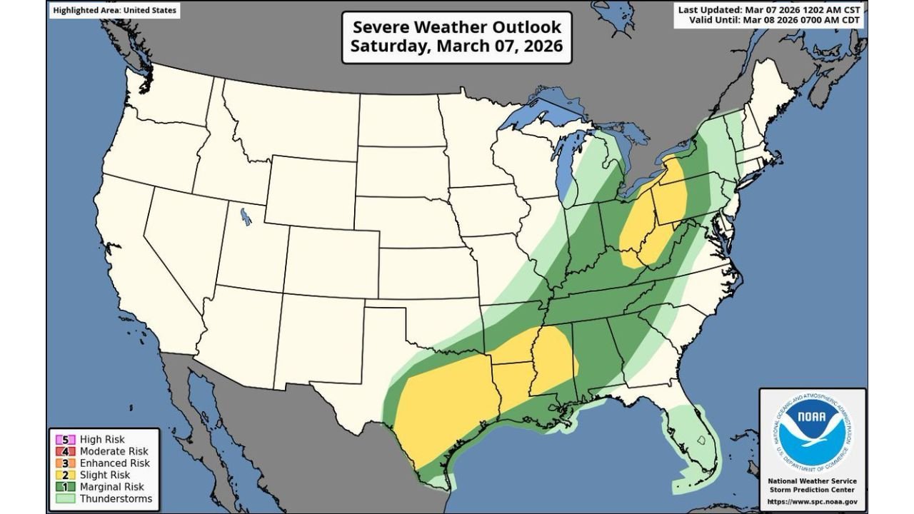
UNITED STATES — A sweeping severe weather setup is unfolding today across a massive portion of the central and eastern United States, placing more than 90 million people under some level of severe storm risk.
The Storm Prediction Center’s outlook highlights a broad corridor stretching from South Texas and the Gulf Coast north and east into the Ohio Valley, Mid-Atlantic, and parts of the Northeast.
Where the Greatest Concern Exists
A concentrated severe zone arcs from:
- South and East Texas, including areas near Houston
- Louisiana and Mississippi, including New Orleans
- Through Alabama, Tennessee, and Kentucky, including Nashville
- Into Georgia and the Carolinas
- Extending northward through Indiana, Ohio, and western Pennsylvania, including Cincinnati and Pittsburgh
A secondary pocket of higher concern is also outlined across portions of the Ohio Valley and central Appalachians, including parts of West Virginia and western Pennsylvania.
Primary Threats Today
Forecasters warn that this system is capable of producing:
- Damaging straight-line winds
- Very large hail
- A couple of strong tornadoes
Storms are expected to develop along and ahead of a strong frontal boundary, with instability and wind shear combining to support rotating thunderstorms in several regions.
Damaging Winds
Widespread thunderstorm clusters may organize into lines capable of producing powerful wind gusts. These winds could down trees and cause scattered power outages, especially across the Deep South and lower Mississippi Valley.
Large to Very Large Hail
Discrete storms ahead of the main line could produce large hail, particularly in areas where stronger updrafts remain isolated before merging into clusters.
Tornado Potential
The tornado threat spans much of the highlighted corridor, with the potential for a couple of strong tornadoes where low-level wind shear is maximized. Areas from the Gulf Coast into parts of the Tennessee and Ohio Valleys will need to monitor conditions closely.
Timing Overview
Storms are expected to intensify through the afternoon and evening hours:
- Southern states will likely see activity ramp up first
- The threat will expand northeastward into the Tennessee and Ohio Valleys later in the day
- Portions of the Mid-Atlantic and Northeast may see impacts as the system progresses east
The risk zone is broad, meaning impacts will vary by location, but the overall environment supports multiple rounds of severe weather.
What This Means for Residents
With such a large population under risk, situational awareness will be critical today. Residents across the affected states should:
- Monitor local weather updates
- Ensure mobile alerts are enabled
- Review severe weather safety plans
- Be prepared to take shelter quickly if warnings are issued
Bottom Line
A large-scale severe weather event is unfolding across the central and eastern United States, impacting over 90 million people from Texas to Pennsylvania. Damaging winds, very large hail, and the potential for strong tornadoes make this a day that demands close attention.
CabarrusWeekly.com will continue monitoring this evolving situation as storms develop across the region.