NWS Confirms EF-0 Tornado Near Banquo, Indiana, With 80 MPH Winds and 1.51-Mile Path Through Huntington and Grant Counties
BANQUO, INDIANA — A brief EF-0 tornado has been confirmed in northern Indiana following a National Weather Service damage survey. The tornado touched down on March 26, 2026, cutting a 1.51-mile path through southern Huntington and northern Grant counties, with no injuries or fatalities reported.
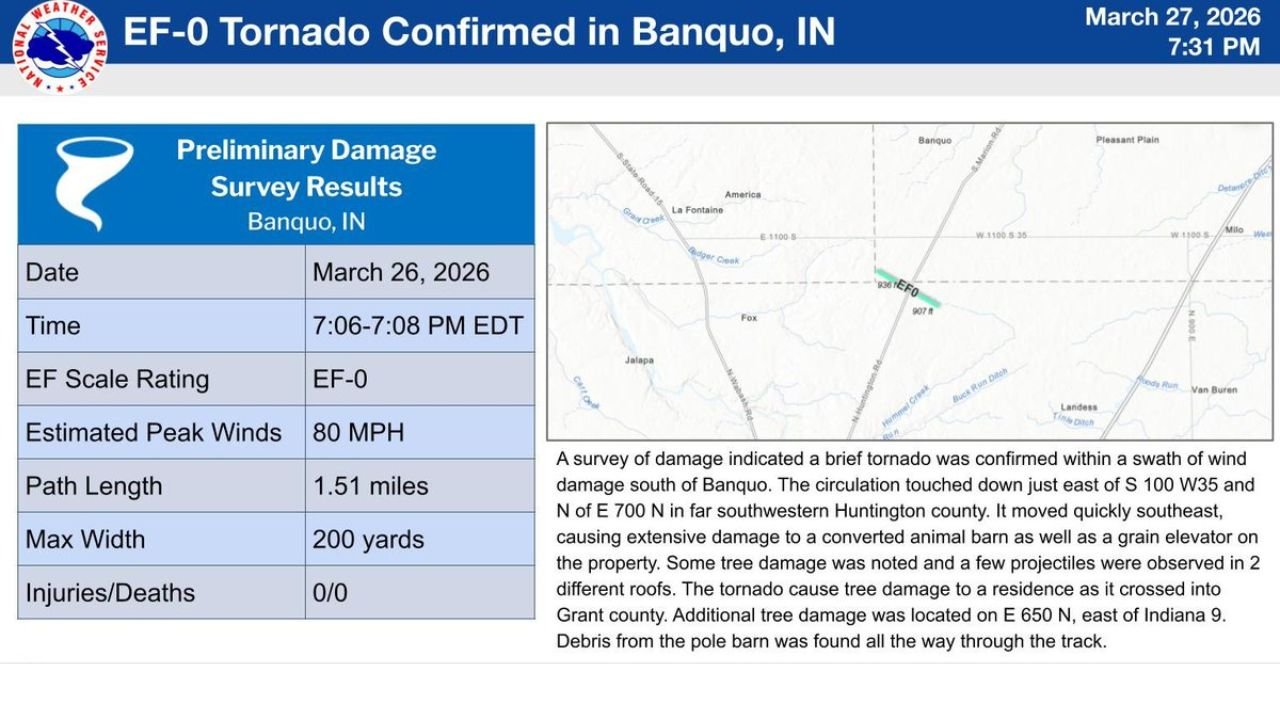
The confirmation was issued by the National Weather Service Northern Indiana office on March 27, 2026 at 7:31 PM EDT.
What Happened and When
The tornado touched down at 7:06 PM EDT and lifted just two minutes later at 7:08 PM EDT — a brief but damaging circulation that left a clear trail of destruction across the rural landscape south of Banquo.
The system touched down just east of S 100 W35 and north of E 700 N in far southwestern Huntington County, moving quickly to the southeast before crossing into Grant County.
Tornado Stats at a Glance
| Detail | Information |
|---|---|
| Date | March 26, 2026 |
| Time | 7:06–7:08 PM EDT |
| EF Scale Rating | EF-0 |
| Estimated Peak Winds | 80 MPH |
| Path Length | 1.51 miles |
| Maximum Width | 200 yards |
| Injuries | 0 |
| Deaths | 0 |
Damage Assessment
Despite its brief duration, the tornado caused significant structural damage along its path.
A converted animal barn and a grain elevator on the same property sustained extensive damage. Tree damage was observed at multiple locations, and projectiles were found lodged in two different roofs along the track.
As the tornado crossed into Grant County, it caused tree damage to a residence. Additional tree damage was documented on E 650 N, east of Indiana 9. Debris from the pole barn was scattered throughout the entire track of the storm.
La Fontaine Area Still Being Assessed
Damage assessment is still ongoing in the La Fontaine, Indiana area. The NWS has confirmed that further details are planned to be released on March 28, 2026 as the survey continues.
Residents in and around La Fontaine should expect updated information from the NWS Northern Indiana office as investigators complete their work in the area.
Forecast Confidence Level
High confidence on the EF-0 rating and all reported statistics — these are official NWS preliminary survey results, not estimates.
Additional details pending for the La Fontaine area — final damage totals and path information may be updated when the full survey is released March 28.
What Residents Should Know
If your property was in the tornado’s path, document all damage with photos before making any repairs and contact your insurance provider as soon as possible.
Stay tuned for updated survey results from the NWS Northern Indiana office on March 28 — additional damage areas in the La Fontaine area may be confirmed.
EF-0 tornadoes, while the weakest on the Enhanced Fujita Scale, are still capable of causing serious structural damage, uprooting trees, and turning debris into dangerous projectiles.
The Bottom Line
An EF-0 tornado with 80 MPH winds briefly touched down near Banquo, Indiana on March 26, carving a 1.51-mile path through Huntington and Grant counties. No one was hurt, but property damage was significant. A full damage survey for the La Fontaine area is expected to be released March 28.
For the latest updates, monitor weather.gov and the NWS Northern Indiana office.
Bookmark cabarrusweekly.com and turn on notifications so you never miss a weather update, storm confirmation, or severe weather report across the United States — delivered daily, before the weather hits.