From Near 90 to the 50s in Days: Baltimore and the Mid-Atlantic Face a Dramatic 40-Degree Temperature Crash After Wednesday and Thursday’s Peak Heat — The Euro Model Shows the Full Swing
BALTIMORE, MARYLAND — The mid-Atlantic region is about to experience one of the most dramatic temperature swings of the year in the span of just a few days. Baltimore will approach 90 degrees on Wednesday and Thursday — the peak of this week’s intense heat event — before the bottom falls out completely. The latest run of the Euro AIFS model shows temperatures crashing into the 50s by Sunday afternoon, delivering a roughly 40-degree temperature collapse from peak heat to weekend cooldown.
The Peak: Wednesday and Thursday Approach 90 in Baltimore
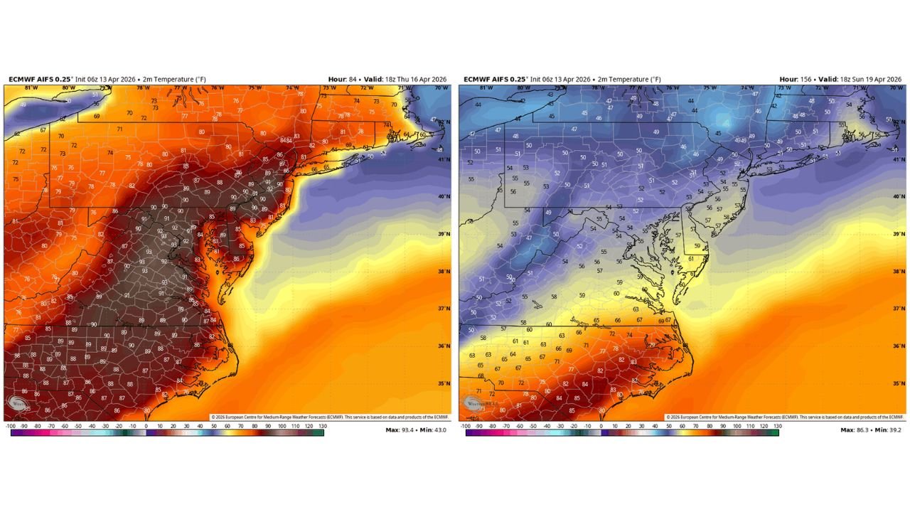
The ECMWF AIFS 0.25 degree model, initialized 06z April 13, 2026, shows the full scope of Thursday’s heat across the mid-Atlantic at 18z April 16, 2026 — the peak of the heat event. The temperature map for Thursday afternoon is dominated by deep red and dark maroon shading, with values clustered in the 90 to 93 degree range across the heart of the region.
| Area | Thursday April 16 Forecast Temperature |
|---|---|
| Central Maryland and Baltimore metro | 90 to 93°F |
| Washington D.C. and surrounding area | 91 to 93°F |
| Northern Virginia and inland areas | 90 to 93°F |
| Southern Virginia | 88 to 93°F |
| Eastern Pennsylvania | 87 to 91°F |
| Delaware and Eastern Shore | 83 to 89°F |
| Coastal New Jersey and New York | 80 to 86°F |
| North Carolina interior | 86 to 90°F |
| Southern New England | 73 to 83°F |
The maximum on the Thursday map reaches 93.4 degrees with a minimum of 43 degrees — illustrating just how sharp the temperature gradient is across the region as the heat dome holds firm inland while cooler ocean air moderates coastal areas. Baltimore and the Washington D.C. corridor sit in the absolute core of the heat, with temperatures running 20 to 25 degrees above normal for mid-April.
The Crash: Sunday Afternoon Drops Into the 50s
What makes this week’s weather story truly remarkable is not just the peak heat — it is how fast it disappears. The same ECMWF AIFS model, valid at 18z Sunday April 19, 2026, shows a transformation so complete it barely resembles the same region from just three days earlier.
| Area | Sunday April 19 Forecast Temperature |
|---|---|
| Baltimore and central Maryland | 54 to 57°F |
| Washington D.C. area | 55 to 57°F |
| Northern Virginia | 52 to 55°F |
| Eastern Pennsylvania | 51 to 55°F |
| Delaware and Eastern Shore | 57 to 61°F |
| New York and New Jersey coast | 53 to 58°F |
| Southern New England | 47 to 55°F |
| Interior Northeast | 45 to 52°F |
| North Carolina coast | 67 to 72°F |
| North Carolina interior | 71 to 85°F |
Baltimore drops from near 90 on Thursday to the mid-50s on Sunday afternoon — a collapse of approximately 35 to 40 degrees in roughly 72 hours. The deep purple and blue shading that blankets the mid-Atlantic and Northeast on Sunday’s map is the visual opposite of Thursday’s dark red heat dome. The maximum temperature on the Sunday map reaches just 86.3 degrees, and that warmth is confined entirely to the Carolinas and points south — far removed from Baltimore and the mid-Atlantic.
The Numbers Tell the Story of This Swing
| Metric | Details |
|---|---|
| Baltimore Thursday peak | Approaching 90°F |
| Baltimore Sunday afternoon | Mid-50s |
| Temperature drop in 72 hours | Approximately 35 to 40°F |
| Thursday model max | 93.4°F |
| Sunday model max | 86.3°F — confined to Carolinas |
| Model used | ECMWF AIFS 0.25 degree |
| Model initialized | 06z April 13, 2026 |
| Thursday valid time | 18z April 16, 2026 |
| Sunday valid time | 18z April 19, 2026 |
Wednesday and Thursday Are the Days to Brace For
Before the crash, the heat peaks. Wednesday and Thursday represent the most intense stretch of this heat event for Baltimore and the broader mid-Atlantic. Temperatures approaching 90 degrees during a week that should normally see highs in the mid-to-upper 60s represent one of the most significant April heat events the region has seen in years.
The combination of anomalous heat — running 20 to 25 degrees above normal — with the rapid collapse that follows means residents of Baltimore, Washington D.C., Northern Virginia, and surrounding areas will experience what amounts to two entirely different seasons within the same week. Wednesday and Thursday feel like the peak of summer. By Sunday, a jacket becomes necessary.
What to Expect Day by Day in Baltimore
| Day | Expected Conditions |
|---|---|
| Monday April 13 | Warm, climbing into the low 80s |
| Tuesday April 14 | Continued warming, mid to upper 80s |
| Wednesday April 15 | Peak heat approaching 90 — record possible |
| Thursday April 16 | Peak heat approaching 90 — record possible |
| Friday April 17 | Heat begins to retreat |
| Saturday April 18 | Cooling trend accelerates |
| Sunday April 19 | Temperatures crash into the 50s |
Stay Tuned — This Pattern Is Still Evolving
The Euro AIFS model is the latest guidance to capture this dramatic swing, but forecasters are clear — stay tuned. The exact timing and depth of Sunday’s cooldown, along with the precise peak temperatures on Wednesday and Thursday, will continue to be refined as the week progresses and additional model runs come in.
What is not in question is the overall pattern. A heat peak near 90 degrees mid-week followed by a stunning drop into the 50s by Sunday is the most likely scenario according to the current guidance, and it represents one of the sharpest week-to-week temperature contrasts Baltimore and the mid-Atlantic have seen in recent memory.
The heat arrives first — and it arrives hard. Then the bottom falls out by the weekend.
Stay with CabarrusWeekly.com for daily temperature updates, record-tracking coverage, and the latest model guidance on Baltimore’s dramatic mid-week heat peak and the rapid cooldown that follows heading into the weekend.