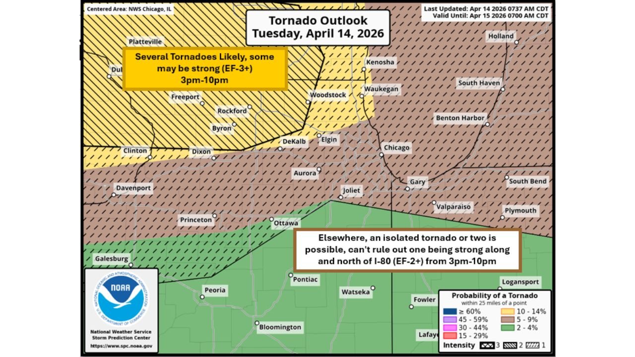
It Could Be a Dangerous Day: NWS Chicago Issues 8 AM Tornado Outlook Warning of Several Tornadoes Likely — Some EF-3 or Stronger — Across Far Northern Illinois and Southern Wisconsin From 3 PM to 10 PM
CHICAGO, ILLINOIS — The National Weather Service in Chicago issued an updated tornado outlook at 8 AM Tuesday April 14, 2026 — and the language is unambiguous. The environment across far northern Illinois, eastern Iowa, and southern Wisconsin is described as extremely primed for supercells capable of strong tornadoes anytime from 3 PM through 10 PM. Several tornadoes are likely in the cross-lined zone, some of which may be strong reaching EF-3 or stronger. Forecasters are closing their statement with five words that carry all the weight needed: it could be a dangerous day.
The 8 AM Tornado Outlook — Valid Until April 15, 2026 at 7:00 AM CDT
The NWS Chicago tornado outlook, last updated April 14, 2026 at 7:37 AM CDT and valid until April 15, 2026 at 7:00 AM CDT, defines two distinct tornado threat zones across northern Illinois, southern Wisconsin, and surrounding areas — each with its own level of tornado activity expected and intensity potential.
Zone One — Several Tornadoes Likely, Some EF-3 or Stronger: 3 PM to 10 PM
The highest danger zone on the outlook is the yellow cross-lined area covering far northern Illinois and southern Wisconsin. This is the area described as extremely primed for supercell tornado development.
The formal outlook language for this zone: Several tornadoes likely, some may be strong at EF-3 or stronger, from 3 PM through 10 PM.
| City | Zone |
|---|---|
| Platteville, Wisconsin | Several Tornadoes — EF-3+ possible |
| Dubuque, Iowa | Several Tornadoes — EF-3+ possible |
| Freeport, Illinois | Several Tornadoes — EF-3+ possible |
| Rockford, Illinois | Several Tornadoes — EF-3+ possible |
| Byron, Illinois | Several Tornadoes — EF-3+ possible |
| Clinton, Illinois | Several Tornadoes — EF-3+ possible |
| Dixon, Illinois | Several Tornadoes — EF-3+ possible |
| Woodstock, Illinois | Several Tornadoes — EF-3+ possible |
| Kenosha, Wisconsin | Several Tornadoes — EF-3+ possible |
| Waukegan, Illinois | Several Tornadoes — EF-3+ possible |
| DeKalb, Illinois | Several Tornadoes — EF-3+ possible |
| Elgin, Illinois | Several Tornadoes — EF-3+ possible |
Every community in and between these cities sits inside the zone where the NWS is forecasting several tornadoes as a likely outcome — not a possibility, not a conditional threat, but a likely outcome — with some of those tornadoes potentially reaching EF-3 intensity or greater.
Zone Two — Isolated Tornado or Two, EF-2 or Stronger Cannot Be Ruled Out: 3 PM to 10 PM
South of the primary cross-lined zone, along and north of Interstate 80, a secondary tornado threat zone covers a broader area of northern and central Illinois and into Indiana. The formal outlook language for this zone:
Elsewhere, an isolated tornado or two is possible — cannot rule out one being strong along and north of I-80 at EF-2 or stronger — from 3 PM through 10 PM.
| City | Zone |
|---|---|
| Aurora, Illinois | Isolated tornado — EF-2+ cannot be ruled out |
| Joliet, Illinois | Isolated tornado — EF-2+ cannot be ruled out |
| Chicago, Illinois | Isolated tornado — EF-2+ cannot be ruled out |
| Gary, Indiana | Isolated tornado — EF-2+ cannot be ruled out |
| Valparaiso, Indiana | Isolated tornado — EF-2+ cannot be ruled out |
| South Bend, Indiana | Isolated tornado — EF-2+ cannot be ruled out |
| Plymouth, Indiana | Isolated tornado — EF-2+ cannot be ruled out |
| Ottawa, Illinois | Isolated tornado — EF-2+ cannot be ruled out |
| Princeton, Illinois | Isolated tornado — EF-2+ cannot be ruled out |
| Watseka, Illinois | Isolated tornado — EF-2+ cannot be ruled out |
| Logansport, Indiana | Isolated tornado — EF-2+ cannot be ruled out |
| Benton Harbor, Michigan | Outer zone |
| South Haven, Michigan | Outer zone |
| Holland, Michigan | Outer zone |
Chicago, Joliet, Aurora, and Gary all sit within the zone where an isolated tornado is possible and where an EF-2 or stronger tornado cannot be ruled out from 3 PM through 10 PM.
Tornado Probability Within 25 Miles of a Point
The tornado probability shading on the NWS outlook map provides additional detail on the geographic concentration of today’s tornado risk across the region.
| Probability Zone | Areas Covered |
|---|---|
| 15-29% within 25 miles | Far northern Illinois corridor — Rockford, Freeport, Byron, Dixon, DeKalb, Woodstock, Elgin, Waukegan, Kenosha |
| 10-14% within 25 miles | Southern Wisconsin, outer northern Illinois, Platteville, Dubuque corridor |
| 5-9% within 25 miles | Broader surrounding area including Chicago, Aurora, Joliet, Gary, Valparaiso |
| 2-4% within 25 miles | Outer edges — South Bend, Plymouth, Logansport, Pontiac, Bloomington area |
The 15-29% probability zone sits directly over the far northern Illinois corridor from Rockford and Freeport through DeKalb, Woodstock, Elgin, and Waukegan — the exact area where the environment is described as extremely primed and where several tornadoes are expected from 3 PM through 10 PM. The intensity hatching on the map denotes Intensity Level 3 in the core zone — the highest intensity designation, reserved for environments capable of producing violent, long-track tornadoes.
The 3 PM to 10 PM Window — A Seven-Hour Tornado Threat
The threat window today runs seven consecutive hours — from 3 PM straight through 10 PM. This is not a brief afternoon pop-up storm situation. This is a prolonged, organized severe weather event that covers the late afternoon commute hours, the dinner hours, the evening hours, and extends well into the night across far northern Illinois and southern Wisconsin.
The seven-hour window means:
- Commuters on the road at 3 to 5 PM across northern Illinois are in the opening of the threat window — the worst time to be caught in a vehicle during a tornado outbreak
- Families at home during the evening hours from 5 to 8 PM are in the heart of the threat window
- People transitioning toward sleep at 9 to 10 PM are still inside the active tornado threat window — alerts must remain active
South of I-80 — Mostly Dry But Not Completely Clear
For areas south of Interstate 80, forecasters offer a different message. Away from the surface low and warm front, forcing will be limited — and most areas south of I-80 should remain dry this afternoon and evening. A few storms could develop in this area, but the organized severe weather threat is concentrated north of I-80 in the cross-lined zone and the EF-2 corridor along and north of the interstate.
This does not mean southern Illinois, central Illinois, and areas well south of the threat corridor can completely ignore today — an isolated storm cannot be ruled out anywhere in the region — but the primary and most dangerous tornado threat today is clearly concentrated in the far northern Illinois and southern Wisconsin corridor.
What Far Northern Illinois and Southern Wisconsin Must Do Before 3 PM
The storms begin at 3 PM. The preparation window is this morning. Every action taken before 3 PM is a life-safety action.
- Identify and physically locate your tornado shelter right now — basement or lowest interior floor interior room away from windows — and walk every member of your household to it so there is no confusion when a warning drops
- Mobile home and manufactured home residents in Rockford, Freeport, Byron, Clinton, Dixon, DeKalb, Woodstock, Waukegan, Kenosha, and Elgin — EF-3 tornadoes will destroy your structure. Evacuate to a substantial building with a basement before 3 PM and do not return until the threat has passed
- Anyone with afternoon commute plans in far northern Illinois — reconsider travel between 3 and 6 PM. Being caught in a vehicle during an EF-3 tornado is a life-threatening situation with extremely limited options for survival
- Have multiple alert methods active before noon — NOAA weather radio, phone alerts from multiple apps, and a trusted contact who can reach you — so that when tornado warnings drop at or after 3 PM you receive them instantly regardless of what you are doing
- Cancel outdoor plans for this afternoon and evening across the entire threat zone — any outdoor activity between 3 PM and 10 PM across far northern Illinois and southern Wisconsin is potentially life-threatening
Tuesday April 14 Tornado Outlook — Full Summary
| Factor | Details |
|---|---|
| Issued by | NWS Chicago |
| Updated | April 14, 2026 at 7:37 AM CDT |
| Valid until | April 15, 2026 at 7:00 AM CDT |
| Threat window | 3 PM through 10 PM |
| Primary zone designation | Several tornadoes likely — some EF-3 or stronger |
| Primary zone cities | Rockford, Freeport, Byron, Clinton, Dixon, DeKalb, Woodstock, Waukegan, Elgin, Kenosha, Platteville, Dubuque |
| Secondary zone designation | Isolated tornado — EF-2 or stronger cannot be ruled out |
| Secondary zone cities | Chicago, Aurora, Joliet, Gary, Valparaiso, South Bend |
| Highest probability zone | 15-29% within 25 miles — far northern Illinois |
| South of I-80 | Mostly dry — limited forcing — a few storms not ruled out |
| Forecaster assessment | It could be a dangerous day |
Several Tornadoes Likely — Some EF-3 or Stronger — 3 PM to 10 PM
The NWS Chicago has spoken clearly at 8 AM Tuesday. The environment across far northern Illinois, eastern Iowa, and southern Wisconsin is extremely primed for supercells producing strong tornadoes from 3 PM through 10 PM. Several tornadoes are likely. Some may be EF-3 or stronger. Chicago, Aurora, and Joliet face an isolated tornado threat with EF-2 potential. And forecasters are ending their statement with the words: it could be a dangerous day.
Rockford, Freeport, Byron, Dixon, DeKalb, Woodstock, Elgin, Waukegan, and Kenosha — you are in the bullseye. Get your shelter identified. Get your alerts active. Get your family prepared. And be underground when those warnings drop between 3 PM and 10 PM.
Stay with CabarrusWeekly.com for live Tuesday severe weather coverage across far northern Illinois and southern Wisconsin, real-time tornado warnings as they are issued by NWS Chicago, and storm reports throughout the dangerous 3 PM to 10 PM tornado threat window.