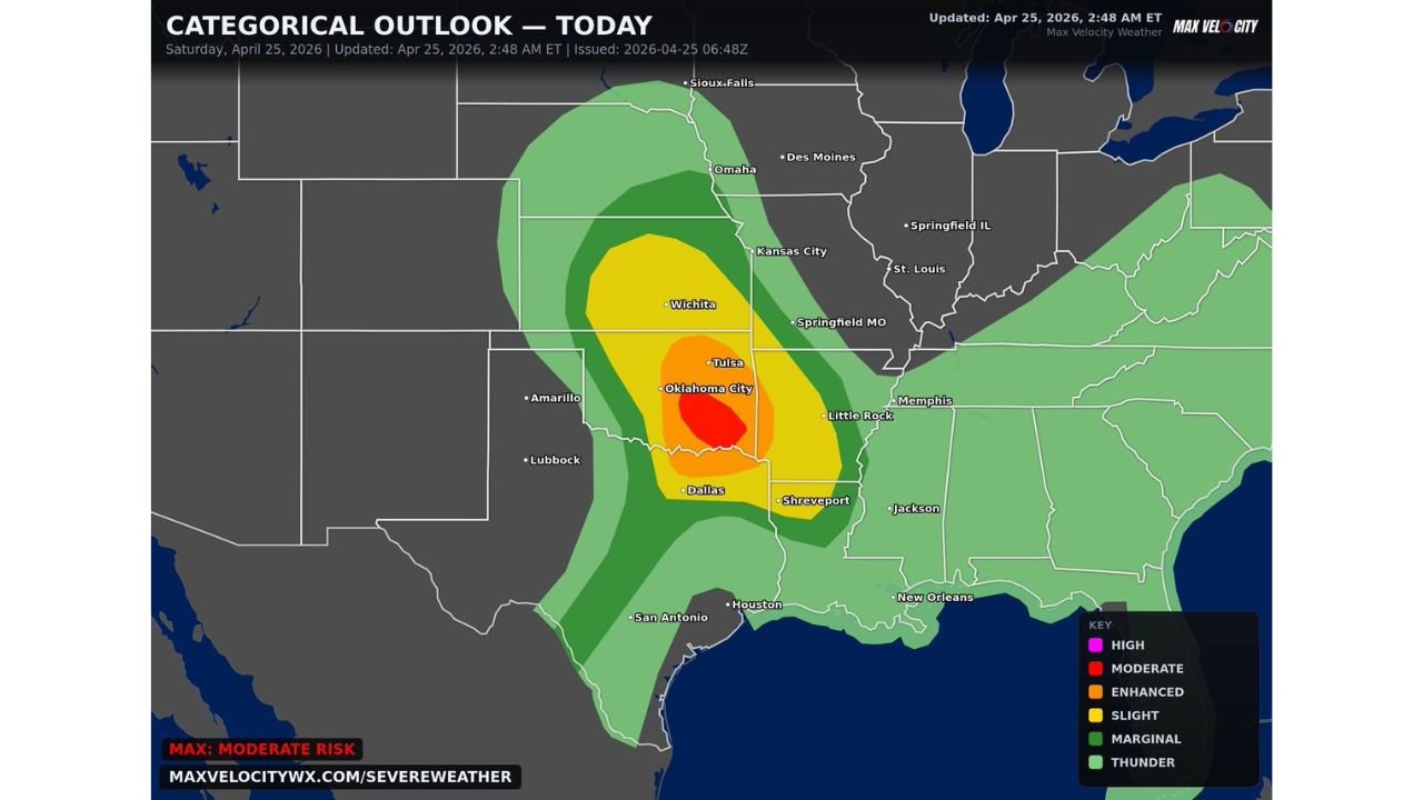
Eastern Oklahoma and North Texas Face 3 to 4 Inch Giant Hail and Intense Tornadoes Today as Oklahoma City and Tulsa Enter the Moderate Risk Bull’s-Eye
OKLAHOMA CITY, Oklahoma — Saturday is not a day to take lightly across eastern Oklahoma and north Texas. Giant hail measuring 3 to 4 inches or larger, damaging winds, and a few strong to potentially intense tornadoes are all on the table today as the most dangerous setup of the week so far targets a corridor running from Dallas north through Oklahoma City, Tulsa, and toward Wichita. The core red Moderate Risk zone sits directly over Oklahoma City and Tulsa — two cities with a combined metro population of well over 2 million people.
This is a very concerning severe weather setup. Prepare now.
The Risk Zone From South to North
The Moderate Risk red core is the second-highest category available and sits over the most densely populated portion of Oklahoma. Moving outward from there, the threat layers across a wide area of the Southern Plains and Mid-South.
Oklahoma takes the direct hit with Oklahoma City and Tulsa inside the red Moderate Risk core. Eastern Oklahoma including McAlester, Muskogee, and Ada sit inside the Enhanced zone surrounding the core. The entire state from Woodward south through the Red River is under some level of formal risk today.
Texas has Dallas inside the Enhanced Risk zone with Shreveport on the eastern fringe. Amarillo and the Panhandle sit on the western edge of the Slight Risk. San Antonio and Houston are on the outer Marginal fringe.
Kansas has Wichita inside the Slight Risk zone with the threat extending north toward Omaha and Des Moines in the outer Marginal territory.
Arkansas and Missouri carry Marginal to Slight Risk with Little Rock and Springfield on the eastern fringe as storms potentially track that direction through the afternoon and evening.
Giant Hail Is the Headline
Three to four inch hail is in a category that causes catastrophic property damage. To put the size in perspective — a golf ball is 1.68 inches. A baseball is 2.9 inches. Four inch hail is larger than a baseball and falls at speeds exceeding 100 mph from a mature supercell. At that size and velocity, it punches through car hoods, shatters windshields completely, destroys roofing materials in seconds, and can cause serious injury or death to anyone caught outside.
Eastern Oklahoma is the specific zone where the 3 to 4 inch hail potential is highest today. The atmospheric profile in this corridor supports the kind of powerful updrafts that suspend hailstones long enough for them to grow to extraordinary sizes before falling. Any vehicle left outside across Tulsa, Muskogee, McAlester, and surrounding communities today faces genuine total loss risk from the strongest supercells.
The Tornado Side of Today’s Threat
Alongside the giant hail, a few strong and potentially intense tornadoes are expected. The language used — maybe intense — reflects the high ceiling on the tornado potential in today’s environment. When supercells develop in a Moderate Risk setup with the atmospheric parameters present across eastern Oklahoma today, the strongest tornadoes they produce can reach EF2 or EF3 intensity.
The warm front position across south-central Oklahoma is the geographic focus for the most dangerous tornado development. Supercells interacting with the warm front have access to extremely sharp low-level wind shear concentrated along the boundary, which dramatically increases their tornado-producing efficiency compared to storms forming in the open warm sector away from any boundary.
Oklahoma City sitting inside the red Moderate Risk zone means any supercell tracking through the metro area on a day like this is immediately life-threatening. The city has faced this scenario before and knows how to respond — but complacency after a week of repeated severe weather threats is the enemy today.
Dallas Needs to Watch the Southern Supercells
Dallas inside the Enhanced Risk zone faces a threat that is somewhat different from Oklahoma City’s situation. Storms forming over north Texas and tracking northeast may stay discrete and tornado-capable longer than storms further north where the atmosphere is more congested. Dallas-Fort Worth metro residents should track the southern supercell development closely through the afternoon for storms approaching from the southwest and west.
Shreveport and Little Rock are on the eastern fringe today but need to monitor radar through the evening as any organized storm clusters track east after dark.
Vehicles Need to Be Under Cover Before Noon
The hail threat window opens this afternoon as supercells fire, but parking situations need to be addressed before storms develop — not after warnings are already issued. Garages, carports, covered parking structures, and any overhead protection are all valuable today. A car cover provides essentially zero protection against 3-inch hail.
If you live or work in eastern Oklahoma or north Texas and your vehicle is currently outside, moving it to covered parking is the single most impactful protective action available before this afternoon.
Shelter Plans Must Be Ready Before Storms Fire
Today’s setup across Oklahoma City and Tulsa is serious enough that every household in these cities should have identified their interior shelter room before noon. Storms can go from initiation to tornado warning within 15 minutes in this kind of environment. Having a shelter plan that requires you to make decisions during a warning wastes precious seconds.
An interior room on the lowest floor, away from windows, with as many walls between you and the outside as possible — that is where you need to be when a tornado warning is issued today. Know exactly where that is before the first storm cloud builds this afternoon.
CabarrusWeekly.com will provide live updates on today’s severe weather across eastern Oklahoma and north Texas as storms develop through the afternoon and evening.