Illinois and Missouri Tornado Outbreak Remains a Realistic Outcome Today as CAPE Surges and StormNet Confirms High Threat
ILLINOIS AND MISSOURI — A significant tornado outbreak remains a realistic outcome for Monday, April 27, 2026 across Illinois and Missouri, with the latest model guidance showing explosive Mixed-Layer CAPE values surging into the deep red and purple range across the primary risk corridor, StormNet tornado probabilities holding at high levels, and the 500mb jet stream positioned at 70 to 80 knots — a range favorable for organized, long-track supercells.
Latest Model Trends Offer Some Encouragement
The most recent HRRR guidance has dialed back the northeastward extent of destabilization compared to earlier runs — a development that reduces the threat for far northeast Illinois and keeps the highest risk more concentrated across central and western Illinois and Missouri. This is a positive trend that forecasters are hoping holds as the event unfolds.
However, the overall picture has not changed meaningfully. A significant tornado outbreak is still a realistic and concerning outcome for today across the core risk zone.
CAPE Values Are Explosive Across the Risk Corridor
Two HRRR Mixed-Layer CAPE maps valid for 9Z and 21Z Monday, April 27 tell a clear and alarming story. A corridor of deep red and purple CAPE values — representing 2,000 to 4,000-plus J/kg of instability — stretches in a concentrated band across western and central Illinois into Missouri and Arkansas. This is the instability that will fuel explosive thunderstorm updrafts capable of supporting large, violent, and long-track tornadoes.
The purple coloring visible on the 09Z HRRR initialization — indicating the highest instability values — is concentrated directly over the Missouri and western Illinois corridor, exactly where the greatest tornado threat is expected to materialize this afternoon.
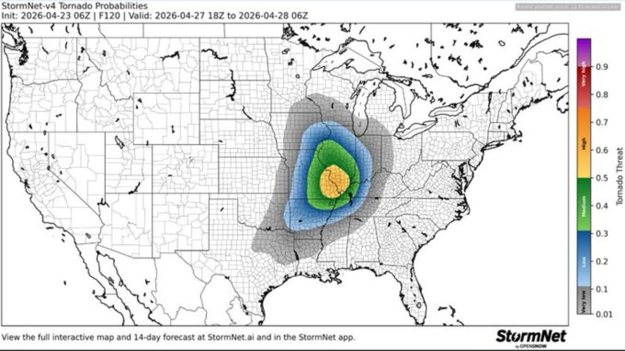
StormNet Tornado Probability Confirms High Threat
The StormNet v4 tornado probability map — initialized April 23 and valid for the April 27 18Z to April 28 06Z window — places the highest tornado probability in the moderate to high range across a corridor centered on Illinois and Missouri, with the core yellow zone indicating probabilities in the 0.5 to 0.7 range across central Illinois and the Missouri border region. A surrounding green zone extends the elevated threat outward across a broader multi-state area.
Jet Stream Positioning Is a Key Factor
The 500mb ensemble mean valid at 16Z Monday shows the jet stream positioned with 70 to 80 knot winds across the primary risk corridor — lower than the 90-plus knot scenario that had briefly appeared in earlier guidance runs. The two orange lines on the jet stream map highlight the jet streak positioning and orientation relative to the outbreak zone.
While 70 to 80 knots is still a strongly supportive wind profile for supercell development and tornado production, the lower end of the range compared to the 90-plus knot scenario does reduce — but does not eliminate — the very highest-end outbreak potential.
What This Means for Today
| Parameter | Current Status |
|---|---|
| Mixed-Layer CAPE | Explosive — deep red and purple across Missouri and western Illinois |
| Tornado Probability (StormNet) | 0.5 to 0.7 — moderate to high across core zone |
| 500mb Jet Speed | 70 to 80 knots — favorable but below worst-case scenario |
| Destabilization extent | Dialing back slightly to northeast — core threat more focused on central Illinois and Missouri |
| Outbreak potential | Significant tornado outbreak remains a realistic outcome |
Residents across central and western Illinois and Missouri remain in the highest-risk zone for today’s event. The afternoon and evening hours are the primary window for the most organized and dangerous storm activity.
Stay sheltered, stay informed, and stay with CabarrusWeekly.com for continuous live coverage throughout Monday’s severe weather event.