Indiana, Illinois and the Midwest Face Cooler Than Normal May With Frost Risk After Today’s Severe Weather Clears
INDIANA AND MIDWEST — Once today’s severe weather threat moves through, a dramatic pattern shift is coming for Indiana, Illinois, and the broader Midwest — with cooler than normal temperatures expected to dominate the entire month of May, a frost risk developing for central Indiana in early May, and the North Atlantic Oscillation locked in a negative phase that will reinforce the cool signal through much of the month.
Severe Chances End Today — Cold Air Moves In
Today’s severe weather marks the end of the active severe pattern for the foreseeable future across Indiana and the Midwest. As colder air settles in behind today’s storm system, severe weather chances will diminish significantly and the pattern flips to a prolonged cooler stretch that will dominate through May.
Frost Risk Coming for Central Indiana in Early May
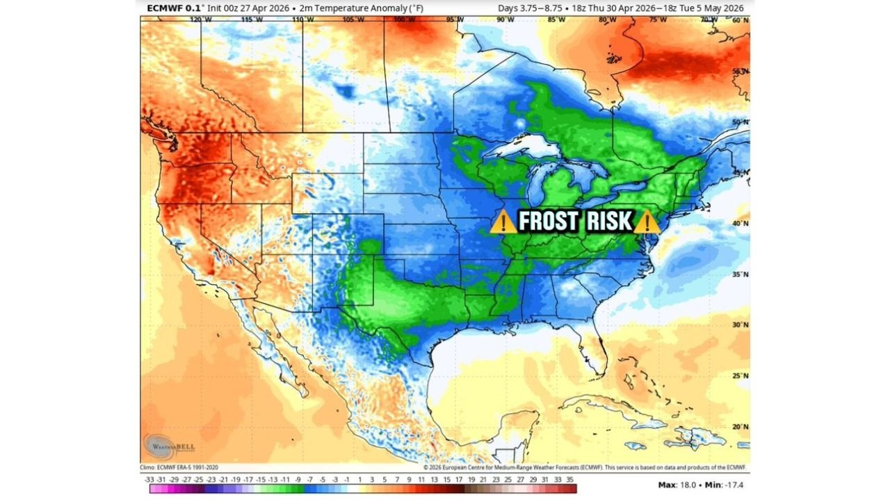
The ECMWF temperature anomaly map valid from April 30 through May 5 shows a broad and deep cold anomaly — depicted in blue and green — blanketing the entire Midwest and central United States. The frost risk is explicitly flagged across Indiana and surrounding states during this period.
Forecasters are warning that central Indiana faces a legitimate frost risk in early May — a significant concern for any early-season plantings, gardens, and agricultural operations across the region. Frost risks are expected to continue through late May across the upper Midwest further north.
A Cool May on Tap Across the Midwest
The extended ECMWF ensemble temperature anomaly map covering April 30 through May 30 tells a clear and consistent story — below normal temperatures are expected to dominate the Midwest for essentially the entire month of May. The blue anomaly field stretching from the Plains through the Great Lakes and into the Ohio Valley confirms this is not a brief cool shot but a sustained, month-long pattern departure.
The only areas bucking this cool trend are parts of the western United States and the far Northeast, which remain near or above normal.
NAO Locked in Negative — the Atmospheric Driver
The North Atlantic Oscillation graph — a key large-scale climate driver — shows both the control run and ensemble mean trending and holding in negative territory through the extended period. A negative NAO is directly associated with a pattern that allows cold air to push southward into the central and eastern United States, reinforcing the cool and below-normal temperature regime that is forecast to dominate through May.
Temperature Outlook Summary for the Midwest
| Period | Expected Conditions |
|---|---|
| Today — April 27 | Severe weather threat — last active severe day |
| Late April 28 onward | Colder air settling in, severe chances diminish |
| Early May — around May 1 to 7 | Frost risk for central Indiana and surrounding states |
| Through Mother’s Day | Frost risk likely done for Indiana after mid-May |
| Late May | Frost risk continues across upper Midwest and northern states |
| Full month of May | Cooler than normal temperatures dominate the Midwest |
What Gardeners and Farmers Need to Know
With frost risks likely for central Indiana in early May, anyone who has already planted warm-season crops, garden plants, or sensitive vegetation should be prepared to protect plantings from potential frost damage during the first week of May. The frost risk is expected to ease after Mother’s Day for Indiana, but the cool pattern persists well beyond that point.
Stay with CabarrusWeekly.com for continuing coverage of the pattern change and what it means for communities across Indiana and the Midwest through May.