Arkansas, Oklahoma, Tennessee and Kentucky Face Level 2 Severe Weather Risk Tuesday With All Hazards Possible
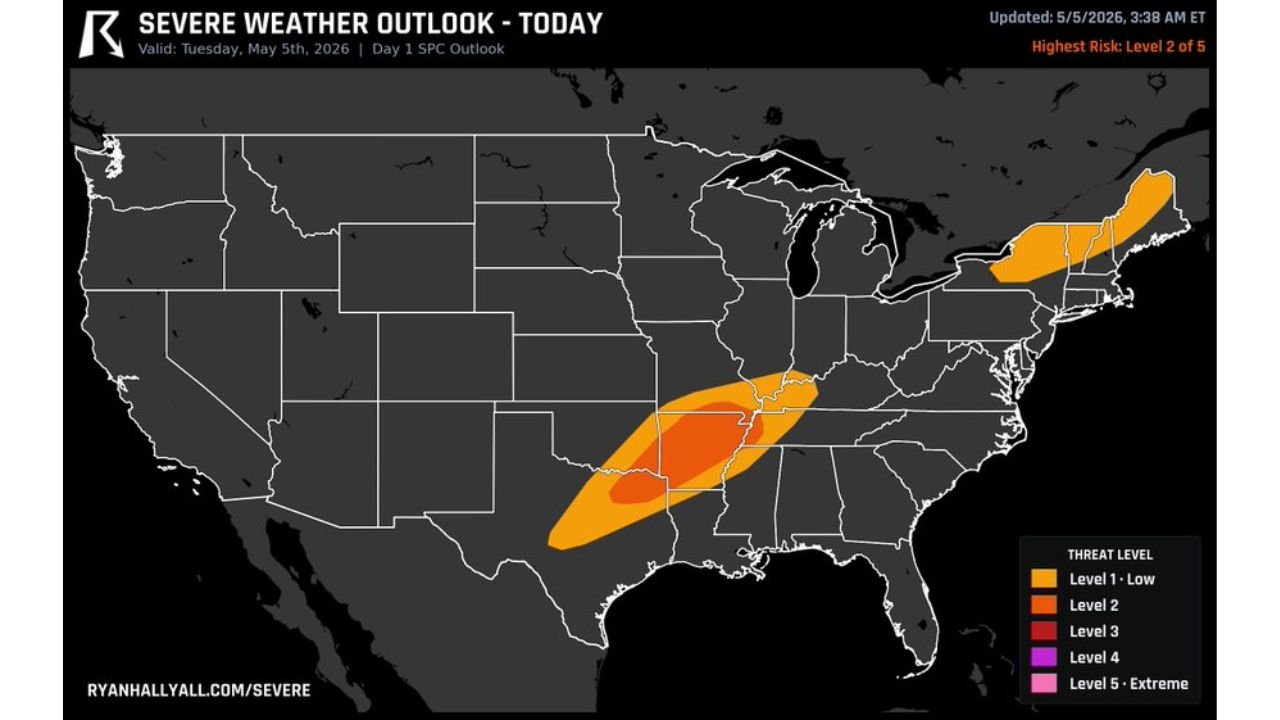
ARKANSAS, OKLAHOMA, TENNESSEE AND KENTUCKY — A serious severe weather threat is in place for Tuesday, May 5, 2026 across Arkansas, Oklahoma, Tennessee and Kentucky, with the Day 1 SPC outlook updated at 3:38 AM ET placing a Level 2 of 5 risk across the core zone and a Level 1 Low surrounding area extending into neighboring states. Residents across all four states are urged to shelter vehicles and keep weather radios active throughout the day and evening.
Level 2 Core Covers Arkansas, Oklahoma, Tennessee and Kentucky
The highest risk zone sits across Arkansas, Oklahoma, Tennessee and Kentucky, with the deeper red Level 2 shading concentrated across the heart of this corridor. A broader Level 1 Low zone surrounds the core, extending the general severe threat into portions of Missouri, Mississippi and Louisiana. A separate Level 1 Low is also in place across upstate New York and New England.
Hazards in Place Today Across the Core Zone
- Tornadoes — possible across the full Level 2 corridor
- Large hail — all sizes possible with stronger storms
- Damaging winds — widespread threat across Arkansas, Oklahoma, Tennessee and Kentucky
Risk Summary Tuesday May 5
| Risk Level | Zone |
|---|---|
| Level 2 | Arkansas, Oklahoma, Tennessee and Kentucky |
| Level 1 Low | Missouri, Mississippi, Louisiana |
| Level 1 Low | Upstate New York and New England |
Residents across Arkansas, Oklahoma, Tennessee and Kentucky should put vehicles in covered shelter now, identify a basement or interior room, and keep weather radios and alert apps active through tonight.
Stay with CabarrusWeekly.com for live Tuesday severe weather updates across Arkansas, Oklahoma, Tennessee and Kentucky.