This Weekend and Next Week, Charlotte, Raleigh, Wilmington, Asheville, and Columbia Head Back Into a Warm Dry Pattern With Highs Near 90 and Barely Any Rain in the 10-Day Forecast
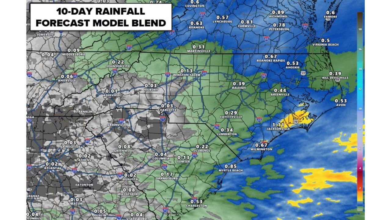
NORTH CAROLINA — After last week’s beneficial rainfall, the Carolinas are heading back into a warm and dry pattern late this week and into next week. The 10-day rainfall forecast is very limited across the region, with highs climbing into the upper 80s to near 90 degrees by the weekend and continuing into next week.
How Little Rain Is Forecast Over the Next 10 Days
The 10-day rainfall model blend shows extremely limited precipitation across the Carolinas and surrounding states:
| City | 10-Day Rainfall Forecast |
|---|---|
| Charlotte | 0.03 in |
| Winston-Salem | 0.13 in |
| Raleigh | 0.39 in |
| Fayetteville | 0.29 in |
| Wilmington | 0.67 in |
| Myrtle Beach | 0.85 in |
| Charleston | 0.53 in |
| Asheville | 0.01 in |
| Columbia | 0.04 in |
| Jacksonville NC | 1.11 in |
Charlotte stands out as one of the driest spots in the entire region at just 0.03 inches over 10 days.
Charlotte Metro Rainfall Through May 22
Detailed forecast data through Friday May 22 at 8:00 AM shows the Charlotte metro area and surrounding communities all sitting in the 0.10 to 0.22 inch range for total accumulated rainfall — confirming the dry stretch ahead:
- Charlotte — 0.10 in
- Huntersville — 0.22 in
- Concord — 0.22 in
- Rock Hill — 0.15 in
- Indian Trail — 0.15 in
- Gastonia — 0.13 in
Warm and Dry Through Next Week
With rainfall totals this low and highs pushing toward 90 degrees by the weekend, the region is shifting into an early summer-like pattern. The combination of heat and limited rain could begin to stress lawns, gardens, and crops across the Carolinas heading into the back half of May.
Stay with CabarrusWeekly.com for the latest forecast updates as this warm and dry pattern builds across the Carolinas.