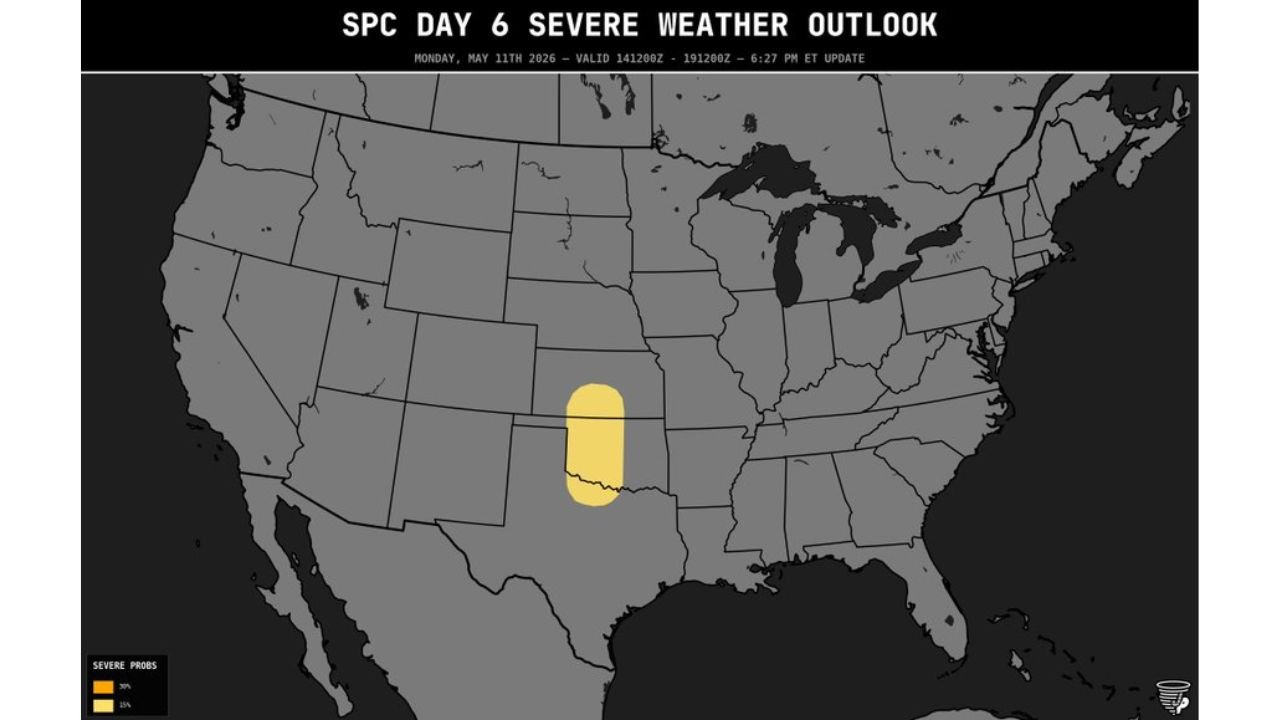
Kansas and Oklahoma Face 15 Percent Severe Weather Risk Saturday May 16 as Active Mid-May Pattern Builds Toward Very Active June
OKLAHOMA CITY, Oklahoma — A 15 percent severe weather probability zone has been outlined for Saturday, May 16, 2026, covering Kansas and Oklahoma as an active mid-May pattern delivers a handful of lower-end severe weather events before what forecasters expect to be a very active June.
The Day 6 outlook valid Saturday, May 16 was updated at 6:27 PM ET Monday, May 11, with the threat zone centered over Kansas and Oklahoma and the broader upper-level pattern strongly supporting continued severe weather chances through the end of May and into June.
What the Saturday May 16 Outlook Shows
The Day 6 severe weather outlook valid Saturday, May 16 shows a 15 percent severe weather probability zone covering a compact but meaningful area:
- The 15 percent severe weather zone is centered over Kansas and Oklahoma, with the risk area stretching from central Kansas southward through Oklahoma in a north-to-south oriented corridor.
- A 15 percent probability means that for any point within the outlined zone, there is a 15 percent chance of a severe thunderstorm occurring within 25 miles of that location during the valid period on Saturday, May 16.
- This is considered a meaningful severe weather threat that warrants preparation and awareness across Kansas and Oklahoma heading into the weekend.
What the Upper-Level Pattern Shows
The atmospheric setup map valid Saturday, May 16 reveals the large-scale weather pattern driving this mid-to-late May active period:
- A strong jet stream is shown tracking across the northern United States with a broad trough of energy digging southward into the Plains region by Saturday, May 16, providing the upper-level support needed for severe thunderstorm development across Kansas and Oklahoma.
- This type of upper-level pattern, with a strong jet stream positioned over the northern states and energy dropping southward into the Plains, is a classic severe weather setup for Kansas and Oklahoma in mid-to-late May.
- The pattern is expected to remain somewhat active through the end of May before amplifying significantly heading into June.
Mid-May Active Period Before a Very Active June
Forecasters are viewing the current mid-May severe weather stretch as a warm-up before what is expected to be a significantly more active period as June arrives:
- A handful of lower-end severe weather events are expected across the Plains and Midwest while the overall weather pattern remains broadened out through mid-to-late May, meaning storms will be somewhat scattered rather than organized into a major outbreak.
- The end of May into early June is expected to see a significant amplification of the weather pattern, with forecasters expressing high confidence that June will be very active for severe weather across the central United States.
- Residents across Kansas and Oklahoma should treat this Saturday, May 16 event as part of an extended active severe weather stretch rather than an isolated occurrence, and maintain their preparedness through the entire late May into June timeframe.
What to Do Before Saturday
Residents across Kansas and Oklahoma within the 15 percent severe weather zone have several days to prepare:
- Ensure weather alert notifications are active on your phone now so any watches or warnings issued Saturday, May 16 reach you the moment they are posted.
- Have a shelter plan ready at home and for any outdoor activities planned for Saturday across Kansas and Oklahoma, as severe thunderstorms capable of damaging winds and large hail can develop quickly within a 15 percent risk zone.
- Continue monitoring daily forecast updates through Friday, May 15 as storm timing, coverage and intensity details for Saturday will sharpen significantly in the 24 to 48 hours before the event.
Cabarrusweekly.com will continue tracking this Saturday, May 16 severe weather outlook across Kansas and Oklahoma and will provide updates as the 15 percent risk zone, storm timing and the broader late May into June active pattern develop.