Texas, Oklahoma, Kansas and Nebraska Face Organized Severe Weather With Damaging Winds, Very Large Hail and Tornadoes From Oklahoma City and Wichita Through Kansas City and Omaha Saturday May 16
WICHITA, Kansas — An organized severe weather threat is appearing increasingly likely for Saturday, May 16, 2026, stretching from Texas northward through Oklahoma, Kansas and into Nebraska, with damaging winds, very large hail and a tornado threat all anticipated across the corridor from Oklahoma City and Wichita through Kansas City and Omaha.
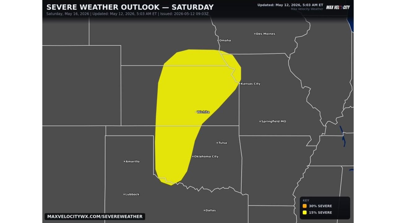
The outlook was updated at 5:03 AM ET Tuesday, May 12, showing a 15 percent severe weather probability zone covering a large north-to-south swath of the central Plains.
Where the Threat Is Focused Saturday May 16
The Severe Weather Outlook for Saturday, May 16 shows the 15 percent risk zone stretching across four states:
- Oklahoma City, Oklahoma and Tulsa, Oklahoma sit within the southern portion of the outlined threat zone, where the severe weather setup will begin developing Saturday afternoon as the system pushes northward.
- Wichita, Kansas falls near the center of the 15 percent risk area and is one of the most exposed cities in the current outlook for Saturday, May 16.
- Kansas City sits near the northeastern edge of the outlined zone, where organized severe storms pushing northward through Kansas could still carry damaging wind, very large hail and tornado potential as they approach the metro area Saturday.
- Omaha, Nebraska is included near the northern tip of the risk zone, placing the city inside the Saturday severe weather outlook as storms track northward through the central Plains.
- Dallas, Texas and Lubbock, Texas sit just outside the southern edge of the current risk area, though the threat zone is still several days away from being finalized and could expand southward in subsequent updates.
- Amarillo, Texas is currently outside the outlined zone on the southwestern edge of the map but should monitor forecast updates closely through the week as the risk area may shift.
Three Threats Anticipated Saturday
Forecasters are anticipating three distinct severe weather threats across the Texas to Iowa corridor on Saturday, May 16:
- Damaging winds are expected with any organized severe storm that develops within the 15 percent zone Saturday, capable of snapping trees, downing power lines and causing structural damage across Oklahoma, Kansas and Nebraska.
- Very large hail is anticipated with this setup, meaning hail reaching 2 inches in diameter or larger is possible across communities from Oklahoma City and Wichita northward through Kansas City and Omaha on Saturday.
- A tornado threat is also anticipated as part of this organized severe weather event, making Saturday, May 16 a day when all residents within the outlined zone should have a shelter plan ready well in advance.
This Threat Is Growing
Forecasters are describing this as a growing risk that is appearing increasingly organized with each new update:
- The combination of damaging winds, very large hail and an anticipated tornado threat places this Saturday, May 16 event above a typical lower-end severe weather day for the central Plains.
- The risk area outlined in this 5:03 AM ET Tuesday, May 12 update is expected to expand, shift and potentially intensify in subsequent outlooks as the storm system comes into sharper focus later this week.
- Residents across Oklahoma City, Wichita, Kansas City and Omaha should treat this as a high-priority severe weather event to prepare for now rather than waiting for later updates.
What to Do Before Saturday
Residents across Texas, Oklahoma, Kansas and Nebraska have 4 days to prepare before this system arrives:
- Enable severe thunderstorm and tornado alerts on your phone now and verify your household shelter plan is ready well before Saturday, May 16.
- If you have outdoor events or travel planned for Saturday anywhere from Oklahoma City through Wichita, Kansas City and Omaha, build a severe weather contingency plan and identify shelter locations along your route.
- Monitor daily forecast updates through Friday, May 15 as storm timing, exact threat types and the expanded risk area will become much clearer in the 24 to 48 hours before the event.
Cabarrusweekly.com will continue tracking this growing organized severe weather threat across Texas, Oklahoma, Kansas and Nebraska including Oklahoma City, Wichita, Kansas City and Omaha and will provide updates as damaging winds, very large hail and tornado details develop ahead of Saturday, May 16.