Kansas, Nebraska and Iowa Face Giant Hail, Damaging Winds and a Strong Tornado Threat Near Omaha, Kansas City and Wichita Saturday May 16 This Afternoon and Evening
KANSAS — All severe hazards are possible across parts of the Plains into the Upper Midwest on Day 3, Saturday May 16, 2026, with the Slight Risk zone centered over a corridor from Wichita and Kansas City north through Omaha and Cedar Rapids. Where storms manage to break through capping, large to giant hail, damaging winds, and a couple of tornadoes are possible with a strong tornado not ruled out near the triple-point where robust storms can tap into better surface moisture.
Where the Threat Is Focused Saturday
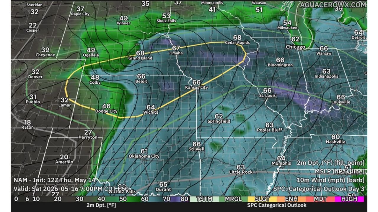
The SPC Categorical Outlook valid at 7:00 PM CDT Saturday May 16 shows the risk zone clearly defined:
- Slight Risk corridor — stretching from Dodge City and Wichita north through Beloit, Grand Island, Omaha, and Cedar Rapids
- Moisture axis — dewpoints of 66 to 68 degrees pooling across Kansas City, Omaha, and Cedar Rapids
- Dryline boundary — evident along the western edge near Colby and Ogallala where storm initiation is most likely
- Cities including Denver, Chicago, Oklahoma City, and Nashville sit outside the current risk zone
Atmospheric Setup Supports Supercells
Sounding data valid at 00Z Sunday May 17 near the 39.59N 96.6W corridor — central Kansas into southern Nebraska — shows a highly favorable supercell environment:
- Surface CAPE: 3937 J/kg — extremely high instability
- SHIP: 3.9 — significant hail parameter at a dangerous level
- STP (cin): 3.1 — strong tornado parameter
- SARS: 66% TOR analog match — two-thirds of similar soundings produced tornadoes
- Potential hazard type: TORNADO flagged directly on the sounding
Key Hazards Saturday
- Giant hail — primary threat where supercells develop
- Damaging winds — possible with any robust storm
- Tornadoes including a strong tornado — cannot be ruled out near the triple-point
Capping Is the Wild Card
Capping will likely keep storm coverage fairly isolated, meaning not every area within the risk zone will see storms. However, any storm that does develop will have access to exceptional instability and shear, making individual supercells capable of all severe hazards simultaneously.
Stay with CabarrusWeekly.com for live updates as this Saturday severe weather threat develops across the Plains and Upper Midwest.