Nebraska, Iowa, Kansas and Oklahoma Face a 2-Day Severe Weather Outbreak With Strong to Intense Tornadoes, Large Hail and Damaging Winds at Enhanced Level 3 Risk Near Omaha, Sioux Falls, Wichita and Oklahoma City Sunday and Monday May 17-18
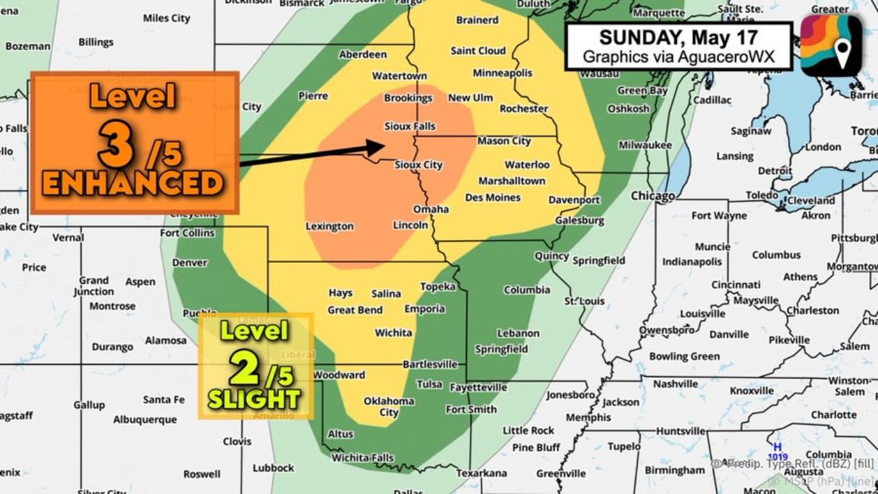
OMAHA, NEBRASKA — A multi-day significant severe weather outbreak is increasingly possible Sunday and Monday May 17 and 18, 2026, with the potential for a couple of strong to intense tornadoes across the Corn Belt and Upper Midwest on Sunday, followed by a bimodal double threat across the Plains and Midwest on Monday. Both days carry an Enhanced Level 3 out of 5 risk across the core threat zones.
Sunday May 17 Enhanced Risk Zone
The Sunday threat is concentrated in the Corn Belt with an Enhanced Level 3 risk centered over:
- Sioux Falls, Sioux City, Omaha, Lincoln, and Des Moines inside the Enhanced core
- Marshalltown, Waterloo, and Davenport on the eastern edge
- Wichita, Topeka, Emporia, and Great Bend inside the Slight Level 2 zone to the south
- Oklahoma City, Tulsa, and Bartlesville in the broader Slight Risk corridor
Monday May 18 Enhanced Risk Zone
Monday brings a bimodal or double bullseye risk with two separate areas of concern:
Northern bullseye:
- Omaha, Lincoln, Des Moines, Marshalltown, and Davenport remain in the Enhanced core
- Sioux Falls, Mason City, and Waterloo in the northern portion
Southern bullseye:
- Southern and central Kansas including Wichita, Salina, and Great Bend where fewer but more intense discrete rotating supercells may develop Monday evening
- Northern Oklahoma also in the southern risk zone
- Fewer storms in this area means less competition and potentially more intense individual supercells
What Is Driving This Outbreak
Multiple waves of low pressure accompanying an eastward-moving cold front will push very warm and moist air ahead of the system, providing exceptional instability. An approaching jet stream dip will add significant wind shear, encouraging storms to rotate.
All Hazards on the Table Both Days
- Strong to intense tornadoes including a couple of significant ones
- Very large hail
- Damaging winds
- Greatest localized impacts will become clearer as the weekend approaches
Stay with CabarrusWeekly.com for daily updates as this major Sunday and Monday severe weather outbreak threat continues to develop.