Central United States Faces Historic First-Ever CIG 2 Severe Weather Outbreak With Violent Tornadoes and Giant Hail Threatening Millions This Monday
UNITED STATES — For the first time in Storm Prediction Center history, a CIG 2 risk of severe weather has been issued on a Day 3 outlook, placing a large stretch of the central and midwestern United States under a historic and dangerous threat heading into Monday, May 18, 2026.
This Is a Forecast That Has Never Happened Before
To understand how significant this is, you have to understand what a Day 3 outlook means. Forecasters are issuing this level of warning two days in advance, which tells us that confidence in a major severe weather event on Monday is already extremely high. The CIG 1-3 outlook format is brand new, introduced by the SPC in March 2026, and this marks the first time the CIG 2 level has ever been reached on a Day 3 forecast in the history of the agency.
What Is Actually Coming and Why It Is So Dangerous
This event is not being driven by a simple storm risk. Forecasters are specifically concerned about two major threats: intense EF-3 or stronger tornadoes and giant hail measuring 2 to 4 inches in diameter. Those are the two factors that pushed this outlook to a CIG 2 rating days before the storms even develop. When forecasters are already talking about violent tornadoes this far in advance, residents need to pay attention.
The Areas That Need to Be on High Alert
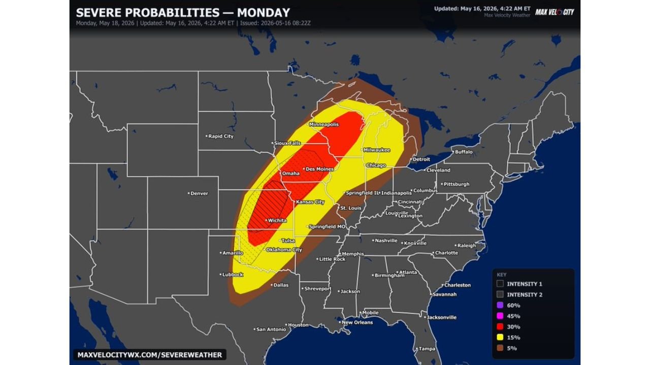
The most dangerous zone on this map sits over portions of Kansas, Nebraska, Iowa, and Missouri, marked as the Intensity 2 hatched area. This is where the risk of violent tornadoes and extremely large hail is highest. Cities directly in or near this zone include Wichita, Kansas City, Omaha, and Des Moines.
Surrounding that core, a 30 percent severe weather probability zone covers a wide area including Minneapolis, Chicago, St. Louis, and Indianapolis. Beyond that, a 15 percent zone pulls in Tulsa and Oklahoma City to the south and Milwaukee and Detroit to the north and east. Even cities further out like Dallas, Memphis, Cleveland, and Pittsburgh are sitting inside the 5 percent zone, meaning they are not completely out of the picture.
A Look at the Full Probability Breakdown
| Probability Level | Cities and Areas Covered |
|---|---|
| 30% | Wichita, Kansas City, Des Moines, Omaha |
| 15% | Minneapolis, Chicago, Tulsa, Oklahoma City |
| 5% | Dallas, Memphis, Cleveland, Pittsburgh |
When This Threat Arrives
This severe weather outbreak is forecast for Monday, May 18, 2026. This outlook was issued on Saturday, May 16, 2026 at 4:22 AM ET, giving the public and emergency managers valuable time to prepare before conditions deteriorate.
What Residents Should Be Doing Right Now
With two days of lead time, there is no reason to be caught off guard. Residents across the entire highlighted region should identify their nearest storm shelter, make sure their weather alerts are turned on, and have a plan in place for Monday. This is a rare and serious setup that forecasters are already watching closely around the clock.
Stay with CabarrusWeekly.com for continuous updates as this historic severe weather threat moves closer to Monday.