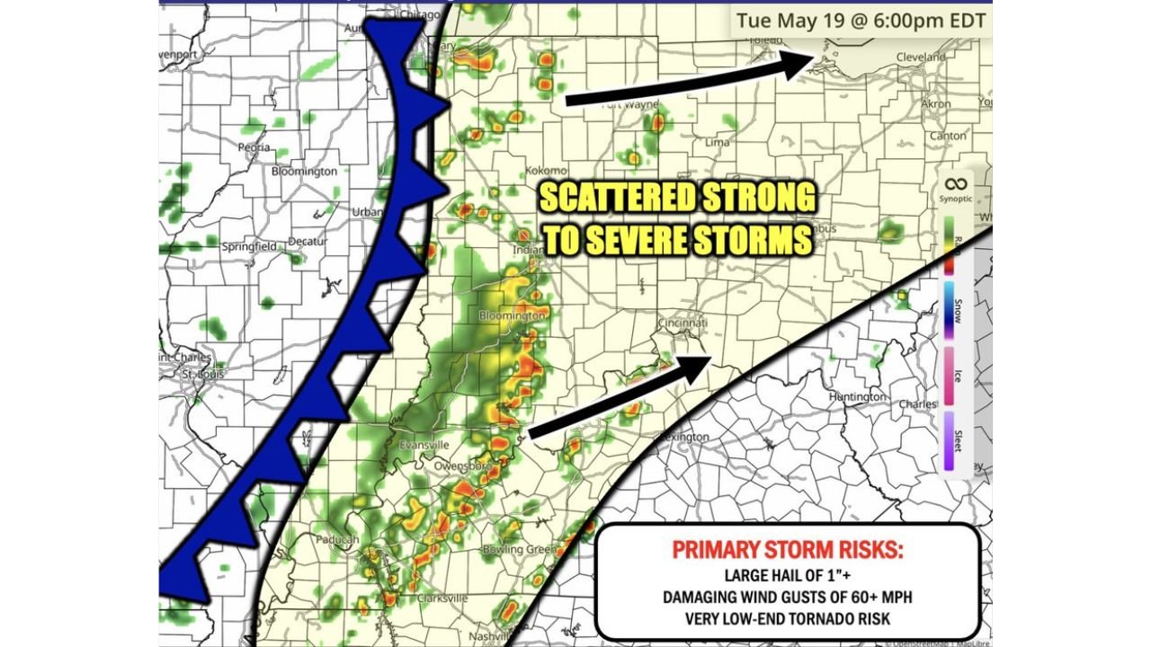
Damaging Wind Gusts of 60 MPH and Large Hail of 1 Inch Targeting Indiana Ohio and Kentucky Including Indianapolis Cincinnati Fort Wayne and Columbus Tuesday Evening by 6PM
INDIANA, OHIO AND KENTUCKY — A second round of scattered strong to severe storms is on the way this Tuesday evening, May 19, 2026, pushing east of an approaching cold front and targeting a wide corridor across Indiana, Ohio, and Kentucky. Simulated radar valid at 6:00 PM EDT shows the storm corridor spreading from the Chicago area southward through Illinois and into Kentucky and Tennessee.
The Three Threats Heading Into Tuesday Evening
Forecasters have identified three specific storm risks for this evening’s activity:
- Large hail of 1 inch or greater
- Damaging wind gusts of 60 mph or more
- Very low-end tornado risk
The primary threat is damaging wind gusts, with large hail as the secondary concern. While a tornado cannot be completely ruled out, that risk remains very low across the affected area this evening.
The Cold Front Is the Trigger
A well-defined cold front is pushing through the region from the northwest this evening, visible stretching from the Chicago area southward through central Illinois and into Missouri and Kentucky. Storms are firing and organizing ahead of and along this boundary, with the most active storm coverage expected across Indiana and Ohio as the front progresses eastward through the evening hours.
Cities Directly in the Storm Corridor
The scattered severe storm threat this evening covers a large area including:
- Indianapolis and Bloomington, Indiana
- Fort Wayne and Kokomo, Indiana
- Columbus and Cincinnati, Ohio
- Toledo and Cleveland, Ohio
- Evansville and Owensboro, Kentucky
- Paducah and Bowling Green, Kentucky
- Peoria and Bloomington, Illinois
- Nashville, Tennessee
- Huntington, West Virginia
What Residents Should Expect This Evening
Storms will be scattered in nature, meaning not every location will see severe weather, but any storm that does develop has the potential to produce 60 mph or stronger wind gusts and hail over an inch in diameter. Residents across the entire corridor should keep weather alerts active through the evening and be prepared to take shelter quickly if a severe thunderstorm warning is issued for their area.
Stay with CabarrusWeekly.com for live updates as Tuesday evening storms move through the region.