Florida Faces Over a Foot of Rain With Isolated 2 Feet Possible June 2 Through June 9 as Models Turn Aggressive on Tropical Moisture Surge
FLORIDA — Models are turning increasingly aggressive with the moisture expected to sit over Florida during the June 2 through June 9, 2026 window, with some areas of Florida very likely to receive over a foot of rain and isolated locations potentially seeing 2 feet or more from training and stalled storms wringing out intense tropical moisture. The likelihood of formal tropical development is decreasing, but the probability of a weak low pressure system forming to surge intense tropical moisture northward is increasing.
What the Precipitation Anomaly Map Shows
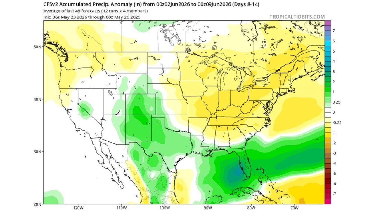
The CFSv2 accumulated precipitation anomaly forecast averaged across 48 model runs initialized from 06z May 23 through 00z May 26, 2026, valid for Days 8 through 14, June 2 through June 9, shows a dramatic moisture signal centered directly over Florida and the Gulf of Mexico.
Precipitation anomaly breakdown by region:
| Region | Anomaly Signal | What It Means |
|---|---|---|
| Florida peninsula | Deep blue, negative 4 to 7 inches anomaly | Extreme above normal moisture concentration |
| Gulf of Mexico | Strong negative anomaly | Moisture pooling and surging northward |
| Central United States | Green, above normal | General above normal precipitation |
| Northern Plains / Canada | Yellow to orange | Below normal precipitation |
| Pacific Northwest | Yellow | Below normal precipitation |
| Southwest United States | Green | Slightly above normal |
| Northeast United States | Yellow to light green | Near to slightly below normal |
The deep blue zone centered on Florida represents one of the most intense precipitation anomaly signals on the map, indicating extreme above normal moisture concentrated over the state during the June 2 through June 9 window.
Rainfall Totals That Could Verify Across Florida
Forecasters are not being cautious with their language on this event. The numbers being discussed are exceptional.
Florida rainfall potential breakdown:
| Scenario | Expected Total |
|---|---|
| Widespread across Florida | Over 12 inches very likely |
| Above average locations | 12 to 18 inches possible |
| Isolated extreme spots | 2 feet or more possible |
| Mechanism | Training and stalled storms |
| Primary driver | Weak low pressure surging tropical moisture northward |
The 2 feet or more isolated total scenario is tied directly to training storms, where multiple storm cells repeatedly pass over the same location, and stalled storm systems that park over an area and continuously wring out the deep tropical moisture overhead.
Tropical Development Picture Has Shifted
The tropical development scenario has evolved over recent days in an important way.
Updated tropical outlook:
| Factor | Current Status |
|---|---|
| Formal tropical development | Likelihood decreasing |
| Weak low pressure formation | Likelihood increasing |
| Impact on moisture delivery | Low pressure still surges moisture northward effectively |
| Tropical storm or hurricane threat | Not the primary concern |
| Primary threat | Extreme rainfall and flooding regardless of development |
The decrease in tropical development odds does not reduce the rainfall threat. A weak low pressure system delivers the same moisture surge northward into Florida with or without achieving tropical storm status. The rain threat is not contingent on tropical development occurring.
Why This Event Is Exceptionally Dangerous Despite Being Welcome
Florida is suffering through the worst drought in over 25 years, making incoming rainfall genuinely needed. However, the extreme totals being forecast create a dangerous paradox.
The drought versus flood paradox:
- Drought-hardened soils have reduced ability to absorb sudden extreme rainfall
- Over a foot of rain in days overwhelms drainage systems regardless of prior drought
- Training storms can drop several inches per hour in localized areas
- Flash flooding can develop rapidly even in drought-stricken areas
- Turn around, do not drown applies even when the region desperately needs rain
- River and creek levels can rise rapidly and dangerously even from a drought baseline
What Florida Residents Must Do Before June 2
With over a week before the main event arrives, preparation time is available now.
- Identify flood-prone areas near your home, workplace, and regular routes
- Never drive through flooded roadways regardless of water depth appearance
- Move vehicles and valuables to higher ground before the event begins
- Have emergency supplies ready including medications, flashlights, and important documents
- Monitor NWS flood watches and warnings which will begin issuing as the event approaches
- Know your evacuation route if you live in a low-lying or flood-prone area
- Stay weather aware throughout the entire June 2 through June 9 window as conditions will evolve daily
Stay with CabarrusWeekly.com for continuing updates on the Florida extreme rainfall threat and tropical moisture surge through June.