Daytona Beach, Florida Slammed by Blinding Rain, 50 MPH Gusts and Lightning as Rainy Season Opens With a Punch at 6 PM
DAYTONA BEACH, FLORIDA — Central Florida’s rainy season made its presence felt immediately on Wednesday, May 28, 2026, as a powerful storm struck Daytona Beach at 6:04 PM, bringing blinding rainfall, wind gusts up to 50 mph, small hail and intense lightning. The storm is producing near-zero visibility conditions on I-95 southbound and has been flagged as the biggest storm on the board across central Florida at the time of reporting.
What Radar Is Showing at 6:04 PM
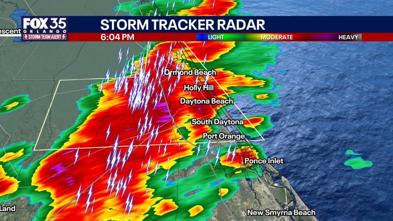
The Storm Tracker Radar at 6:04 PM shows a deep red and purple core sitting directly over Daytona Beach, Holly Hill and Ormond Beach, with the heaviest reflectivity values indicating extremely heavy rainfall at the storm center. The radar footprint extends across:
- Ormond Beach and Holly Hill directly in the core
- Daytona Beach under the deepest purple and red returns
- South Daytona and Port Orange on the southern edge
- Ponce Inlet showing a secondary heavy cell
- New Smyrna Beach in the outer rain shield
Hundreds of lightning strikes are visible across the radar display, concentrated in a dense corridor running from inland areas straight through the Daytona Beach coastline and offshore into the Atlantic.
I-95 Conditions: Nearly Impassable
A Florida 511 traffic camera on I-95 Southbound at Mile Marker 267.0 confirms what radar is showing. The camera image captures near-zero visibility with vehicles barely visible through the wall of rain. Headlights are visible only at very close range, and driving conditions on this stretch of I-95 are extremely dangerous.
Drivers in the area are urged to:
- Pull off the road safely if visibility drops to dangerous levels
- Do not attempt to drive through blinding rain at highway speeds
- Turn on hazard lights if pulling over to the shoulder
- Wait for the storm to pass before resuming travel
Hazards With This Storm
- Wind gusts up to 50 mph capable of downing tree limbs and causing minor structural damage
- Small hail likely occurring at the time of reporting
- Blinding rainfall reducing visibility to near zero
- Frequent and intense lightning across the entire storm footprint
Rainy Season Arrives With Force
This storm marks the official arrival of Florida’s rainy season for central Florida, and forecasters note it is living up to expectations from the start. With drought conditions affecting a large portion of the state, the rainfall is welcome relief despite the storm’s intensity.
Stay with CabarrusWeekly.com for continuing updates as rainy season storms develop across central Florida.