Alabama, Mississippi, Georgia and Tennessee Could Push Into the 80s by Feb. 21–22 as Winter’s “Deep Freeze” Fades Across the South
UNITED STATES — A late-winter pattern shift is signaling that the South may be running out of time for another true “deep freeze,” with guidance and historical analogs pointing toward a major warmup that could bring 80-degree highs to parts of Alabama, Mississippi, Georgia, and Tennessee around February 21–22.
What the Trend Is Pointing To Right Now
The outlook shared in the data describes a clear direction: while exact temperature numbers can’t be locked in more than a week out, current analogs—past years with similar setups—are leaning toward a significant warm surge rather than a return to arctic-style cold.
In other words, the broad pattern is lining up in a way that favors spring-like air making a strong push into the South.
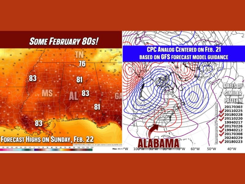
Where the Warmest Readings Are Showing Up
A forecast high-temperature map for Sunday, Feb. 22 shows the warmest values concentrated across the Deep South:
- Mississippi (MS): highs shown near 83°F
- Alabama (AL): highs shown near 81–83°F
- Georgia (GA): highs shown near 81°F
- Tennessee (TN): highs shown around the mid-to-upper 70s, including a value near 76°F
That combination suggests a warm core centered on MS/AL/GA, with TN warm as well, just not as aggressively in the 80s on that specific day.
Why Forecasters Are Watching the Feb. 21 Pattern
The second panel highlights a CPC analog centered on Feb. 21, described as being based on GFS forecast model guidance. The map presentation is paired with a list of similar pattern years/dates, reinforcing the idea that the current setup resembles prior late-winter transitions that often produced at least a day or two of 80-degree weather in the South.
This doesn’t guarantee the exact same outcome every time—but it’s a strong clue that the atmosphere may be trying to flip into a more springlike mode.
What About Severe Weather With a Warm Surge?
The data also makes an important point: in many similar years, severe weather did not immediately follow the warmup. Some past seasons did go on to produce memorable spring storms later, but the warm pattern alone isn’t an automatic severe-weather trigger in the short term.
That’s why the takeaway here is mostly about the temperature regime change—with storm potential something to watch over time, not a certainty tied to the first warm burst.
The Bottom Line for the South
The message of the pattern is that winter threats may be entering the “two-minute warning” phase across the South. With 80s looking more plausible than a rapid return to deep cold, the most likely near-term story is a late-February warmup peaking around Feb. 21–22, especially across Alabama, Mississippi, and Georgia, with Tennessee also trending unusually mild.
If you’re in the South, are you ready for an early taste of 80-degree weather—or were you hoping winter had one last surprise left? Share what you’re seeing in your area and follow more updates at CabarrusWeekly.com.