Alabama Faces Mix of Sun and Storms Through Memorial Day Weekend as Southeast Alabama Sits Under Marginal Risk With Gusty Winds and Heavy Rain Possible
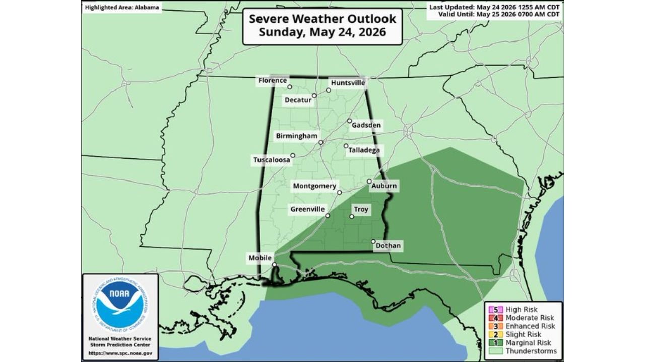
ALABAMA — A mix of sun and thunderstorms will define Alabama’s weather through the remainder of the Memorial Day weekend, with the most significant storm threat focused on Southeast Alabama where the Storm Prediction Center has issued a Marginal Risk level 1 of 5 valid through Monday May 25, 2026 at 7:00 AM CDT.
Active Radar Already Showing Storms Moving Through Southwest Alabama
Live radar data valid at 1050z Sunday May 24, 2026 shows a batch of rain and thunderstorms currently pushing through Southwest Alabama, with the heaviest reflectivity values concentrated along a north-south corridor through the southwestern portion of the state. This activity is expected to diminish over the next few hours before afternoon storm development begins.
Where the Severe Weather Risk Is Focused Today
The SPC Severe Weather Outlook for Sunday May 24, 2026 makes the threat zones clear.
Risk breakdown by area:
| Risk Level | Zone | Areas Included |
|---|---|---|
| Marginal Risk (1/5) | Southeast Alabama | Auburn, Troy, Dothan, Mobile |
| General Thunderstorms | Central and North Alabama | Birmingham, Montgomery, Tuscaloosa, Huntsville |
| No Risk Outlined | Far North Alabama | Florence, Decatur |
The highest potential for strong storms this afternoon and tonight sits squarely over Southeast Alabama. No tornado threat exists, but stronger storms will be capable of producing:
- Gusty winds
- Heavy rainfall
- Frequent lightning
Temperatures Stay Warm Through the Holiday Weekend
The NBM temperature forecast for Birmingham-Shuttlesworth International Airport shows a consistent warm pattern through the extended period.
Daily high and low temperature forecast:
| Date | High (F) | Low (F) |
|---|---|---|
| Sun May 24 | 81 | 66 |
| Mon May 25 | 79 | 66 |
| Tue May 26 | 81 | 66 |
| Wed May 27 | 84 | 67 |
| Thu May 28 | 86 | 67 |
| Fri May 29 | 83 | 67 |
| Sat May 30 | 82 | 66 |
| Sun May 31 | 81 | 63 |
| Mon Jun 1 | 81 | 63 |
| Tue Jun 2 | 81 | 62 |
| Wed Jun 3 | 82 | 61 |
Highs will remain in the mid 80s through most of the week, peaking at 86 degrees on Thursday May 28. Overnight lows stay in the mid 60s through the holiday period.
What to Expect Through the Rest of the Week
The pattern does not change dramatically through mid-week. Residents across Alabama should expect:
- Partly sunny skies with warm and humid conditions each day
- Daily rounds of scattered showers and thunderstorms continuing through Wednesday
- No major severe weather setups anticipated through mid-week
- Gradual warming trend with highs climbing toward the mid 80s by Wednesday and Thursday
Drier and Warmer Weather Possible by Next Weekend
Global models are signaling a pattern shift toward the end of the week. The upper ridge is expected to begin rebuilding late in the week, which would bring a trend toward drier and warmer conditions by the weekend of May 30 and 31.
If that trend verifies, Alabama could see a meaningful break from the daily storm chances that have dominated the pattern through the Memorial Day period, with clearer skies and climbing temperatures heading into the first weekend of June.
Stay with CabarrusWeekly.com for continuing updates on Alabama’s Memorial Day weekend weather and the evolving forecast through the end of May.