East Coast Set for Notable Warm-Up After Early March Chill, But New England Faces Cold Air Damming Uncertainty
UNITED STATES — A legitimate warm-up signal is emerging across much of the East Coast heading into the latter half of the first half of March, but New England remains a wildcard as lingering cold air may complicate the forecast.
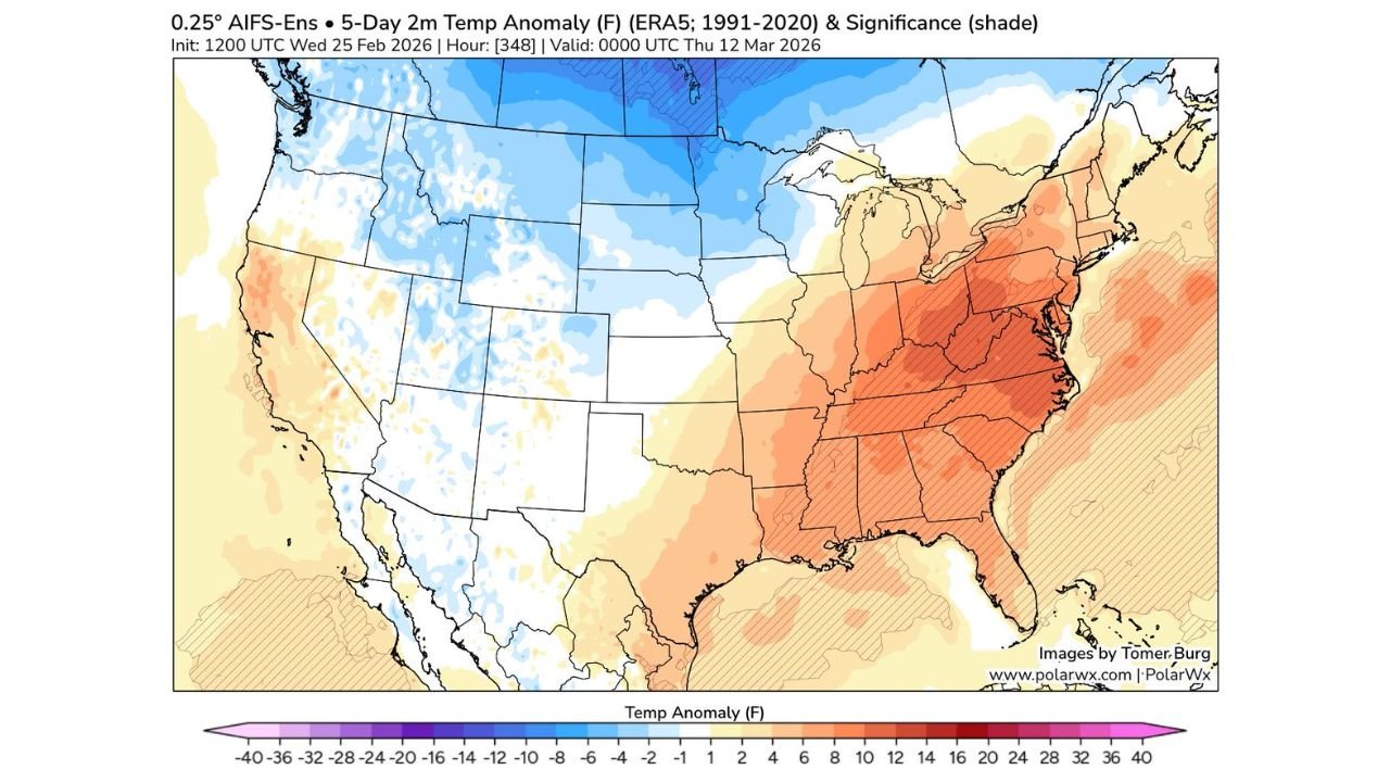
The latest 5-day temperature anomaly guidance shows widespread above-average temperatures developing across the Southeast, Mid-Atlantic, and parts of the Ohio Valley. However, confidence drops farther north into New England.
Strong Warm Anomalies From the Gulf Coast to the Mid-Atlantic
The temperature anomaly map highlights:
- Broad positive departures from normal across Texas, the Gulf Coast, and the Southeast
- Stronger warm anomalies across Alabama, Georgia, Tennessee, the Carolinas, Virginia, and West Virginia
- Continued warmth extending north into Pennsylvania, Maryland, and parts of New York
Much of this corridor is shaded in orange to red tones, indicating temperatures running several degrees above seasonal averages during the forecast window.
The Mid-Atlantic region, including Washington, D.C., Baltimore, Richmond, and Raleigh, appears positioned for a meaningful warm-up if the pattern verifies.
New England’s Forecast: Warmer on Paper, Tricky in Reality
While ensemble averages show slightly above-normal temperatures in parts of New England, the map lacks strong statistical confidence shading in that region.
That absence suggests:
- More than 10% of ensemble members still project below-average temperatures
- Greater uncertainty compared to the Southeast and Mid-Atlantic
- Potential for competing air masses
One key concern is cold air damming, a common March phenomenon in New England. This occurs when cooler, denser air becomes trapped near the surface, especially along the eastern slopes of the Appalachians.
If cold air damming persists:
- Surface temperatures could remain cooler than model averages suggest
- Coastal and inland New England may struggle to fully realize the warm surge
- Temperature gradients could sharpen along frontal boundaries
Western U.S. Remains Cooler
At the same time, the anomaly map shows:
- Below-average temperatures across parts of the Northern Plains and Upper Midwest
- Cooler-than-normal conditions across portions of the Rockies
This contrast reinforces a classic transitional March pattern, with warmth building east of the Rockies while colder air lingers to the north and west.
What This Means for the East Coast
For much of the East Coast south of New England, confidence is increasing in a meaningful warm-up. This could mean:
- Springlike afternoons across the Southeast
- Milder overnight lows
- Accelerated snowmelt in areas that recently saw winter storms
However, in New England, forecasters will closely watch:
- The strength of any backdoor cold fronts
- Surface high pressure positioning to the north
- The potential persistence of shallow cool air
Still Time for Adjustments
While the overall warm signal is legitimate and supported by ensemble means, early March patterns can shift quickly.
Small changes in storm tracks or frontal timing could alter how far north the warmest air ultimately reaches.
Residents along the East Coast should monitor updates over the coming days as forecast confidence increases and finer-scale details become clearer.
Stay with CabarrusWeekly.com for continued coverage as the early March temperature pattern evolves.