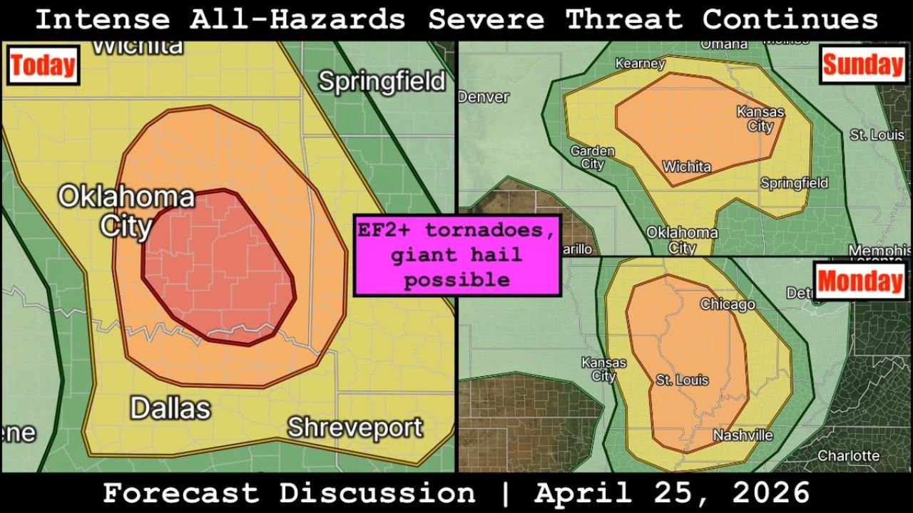
Three Days, Three Bull’s-Eyes Oklahoma City Today, Wichita Sunday, St. Louis Monday as the All-Hazards Outbreak Refuses to Stop
OKLAHOMA CITY, Oklahoma — Three consecutive days. Three separate high-risk zones. Three different regions of the country facing EF2 or stronger tornadoes and giant hail. The all-hazards severe weather outbreak that began Saturday across southeast Oklahoma and northeast Texas is not a single event — it is a rolling, three-day catastrophe in slow motion that shifts its bull’s-eye east with each passing day.
Today’s core sits over Oklahoma City and Dallas. Sunday’s core shifts north to Wichita and Kansas City. Monday’s core pushes east to St. Louis, Chicago, and Nashville. Every one of those cities faces the same label on the forecast map: EF2 or greater tornadoes and giant hail possible.
Today — Oklahoma City and Dallas Are the Bull’s-Eye
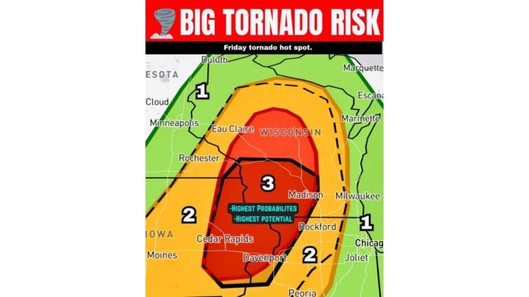
The Saturday map shows the most concentrated risk zone of the three-day sequence, with a dark red inner core sitting directly over Oklahoma City and the surrounding metro extending south toward Dallas and Shreveport. This is the zone that already received the SPC upgrade to EF3 potential across the Ada-Durant-Hugo corridor in southeast Oklahoma.
Supercells near a warm front are the mechanism today. Warm fronts create a sharp boundary in the low levels of the atmosphere where wind direction changes dramatically over a very short distance, producing intense localized wind shear that spinning supercells can exploit to produce violent tornadoes. The warm front position across south-central Oklahoma today is the geographic focus of the most dangerous tornado potential.
Dallas sits in the broader Enhanced Risk zone on today’s map. A supercell that fires over southeast Oklahoma and tracks southeast could cross the Red River into north Texas while still in a favorable tornado environment.
Sunday — The Bull’s-Eye Jumps to Wichita and Kansas City
The Sunday panel shows the core risk zone shifting dramatically northward, now centered over Wichita and extending north through Kansas City toward Omaha and Denver on the western fringe. The same pink label applies: EF2 or greater tornadoes and giant hail possible.
Oklahoma City remains in the outer threat zone Sunday, meaning communities there face back-to-back severe weather days with no recovery time between them. The Sunday setup is driven by a fresh atmospheric disturbance moving through rather than a weakened remnant of Saturday’s system, which means Sunday’s energy is essentially independent and could be just as dangerous as Saturday’s in the right storm mode.
Springfield, Missouri sits on the eastern edge of Sunday’s Enhanced zone. The threat corridor from Wichita through Kansas City to Springfield covers a densely populated swath of the Central Plains and Ozarks.
Monday — St. Louis, Chicago and Nashville Close Out the Outbreak
The Monday panel shows the entire severe weather theater shifting east into the Mid-Mississippi Valley and Ohio River Valley. The Enhanced Risk core now covers St. Louis, Kansas City in its western fringe, and extends south toward Nashville and Memphis. The broader Slight and Marginal zones reach Chicago, Detroit, and into Indiana.
This is the event that has been building in the forecast data all week — the widespread, significant outbreak across the Midwest and Mid-South that multiple data sets have been flagging as a high-confidence threat. Monday continues to look like the most widespread of the three days based on the geographic extent of the threat zone, even if Saturday’s local intensity in southeast Oklahoma may be more concentrated.
Nashville sits on the southern edge of Monday’s core zone. Memphis is inside the broader threat area. Communities in southern Illinois and western Kentucky sit directly inside the Enhanced Risk.
The Warm Front Is the Thread Connecting All Three Days
The same warm front that is focusing Saturday’s tornado threat over south-central Oklahoma is the atmospheric feature that drives the entire three-day sequence. As this front lifts northward through Sunday and Monday, it carries the zone of maximum tornado potential with it. Saturday it sits over Oklahoma. Sunday it has lifted into Kansas. Monday it reaches Missouri and Illinois.
Supercells firing along and near this front on each day will have access to the sharp low-level wind shear that the boundary provides. That is why EF2 or stronger tornadoes remain possible across all three days despite the geographic shift of over 600 miles from Saturday’s bull’s-eye in southeastern Oklahoma to Monday’s bull’s-eye over St. Louis.
What Three-Day Outbreak Fatigue Looks Like and Why It Is Dangerous
By Sunday afternoon, communities in Kansas and Missouri will have watched two days of tornado and hail coverage from Oklahoma and Texas. There is a strong psychological tendency to assume that the worst is over after watching a major severe weather event. The data says the opposite is true. Sunday’s Wichita threat is not the tail end of Saturday’s system — it is a fresh, fully loaded setup in its own right.
By Monday, St. Louis and Chicago residents will have watched three days of severe weather coverage. The temptation to treat Monday as background noise after a week of outbreak coverage is the most dangerous possible response. Monday’s system has been called a widespread significant event by multiple forecast sources. It deserves the same preparation urgency that Oklahoma City gave Saturday.
Three days. Three bull’s-eyes. One continuous atmospheric pattern that is moving east and taking everything it has with it.
CabarrusWeekly.com will track all three days of this outbreak and provide continuous updates as the severe weather corridor shifts from Oklahoma through Kansas to Missouri and Illinois.