Michigan, Indiana, Ohio Face Increasing Severe Storm Risk Tuesday With Damaging Winds, Large Hail and Isolated Tornado Potential
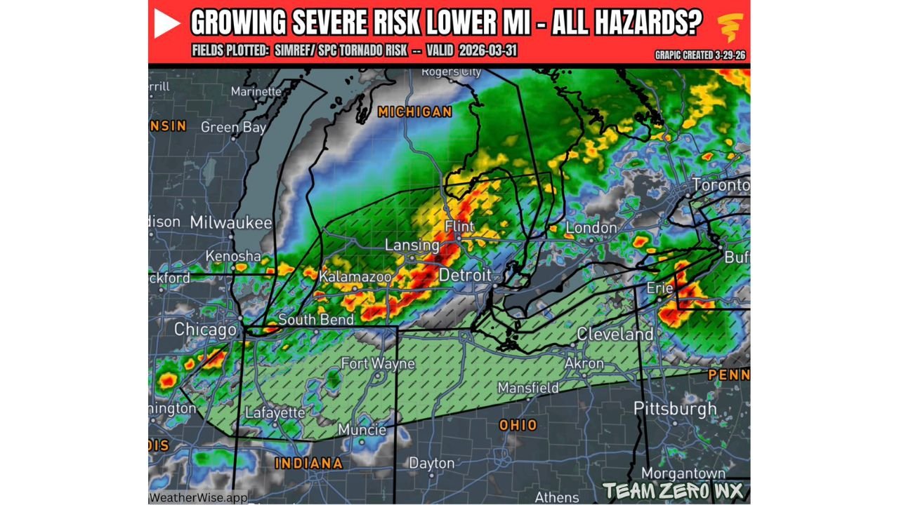
MICHIGAN — A strengthening severe weather setup is expected to impact the Great Lakes region on Tuesday, with southern Michigan at the center of an increasing threat for damaging winds, large hail, and a low-end tornado risk.
Strong Storm Line Develops Along Cold Front
Forecast guidance shows a well-defined line of storms forming along a cold front, pushing eastward across Indiana into southern Michigan and northern Ohio during the day Tuesday.
This line is expected to become strongly forced, meaning storms will organize into a more continuous band capable of producing widespread impacts as it moves through major population centers.
Cities including Detroit, Lansing, Kalamazoo, and Flint are positioned directly in the path of this developing line.
Damaging Winds and Large Hail Lead Main Threats
The primary hazards with this system will be damaging straight-line winds and large hail, especially within the most intense segments of the storm line.
Wind gusts could become strong enough to cause localized damage to trees, power lines, and structures, while hail may develop in embedded stronger cells.
These threats are expected to be most widespread as storms mature along the frontal boundary.
Low Tornado Risk Could Increase With Discrete Storms
While the overall tornado risk remains low, it is not zero.
If any storms are able to form ahead of the main line, they could become more isolated and tap into a strongly sheared environment.
In that scenario, a brief tornado or two cannot be ruled out, particularly across parts of southern Michigan and northern Indiana.
Storms Continue East Into Ohio by Evening
As the system progresses, storms will move east into northern Ohio and toward western Pennsylvania during the late afternoon and evening hours.
Cities such as Cleveland and surrounding areas may see storms later in the day, extending the severe weather window into the evening.
This progression means multiple states across the region will experience impacts within a relatively short timeframe.
Increasing Confidence in Active Weather Day
Confidence is continuing to increase that Tuesday will bring an active and potentially impactful severe weather day across the Great Lakes region.
While not expected to be an extreme outbreak, the combination of organized storms and multiple hazards makes this a situation worth monitoring closely.
Residents should remain alert throughout the day as conditions evolve, especially in areas near the path of the advancing cold front.
Stay with CabarrusWeekly.com for continued updates, and share what conditions you are seeing in your area as storms move through the Great Lakes.