The Severe Weather Train Rolls On: Damaging Winds, Large Hail, and a Potential Elevated Tornado Threat Keep Wednesday Dangerous from Texas and Oklahoma Through the Plains and Into the Great Lakes
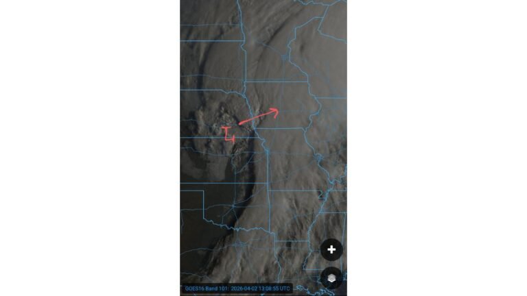
UNITED STATES — The severe weather outbreak that defined Tuesday is not finished. Wednesday April 15, 2026 brings another round of dangerous storms across a corridor stretching from Texas and Oklahoma north through the Plains and into the Great Lakes region. Damaging winds and large hail headline the hazards, and forecasters are warning that an elevated tornado threat could also develop depending on how quickly early morning convection clears — making Wednesday a day that demands continued attention across a large portion of the country.
Wednesday’s Severe Weather Threat at a Glance
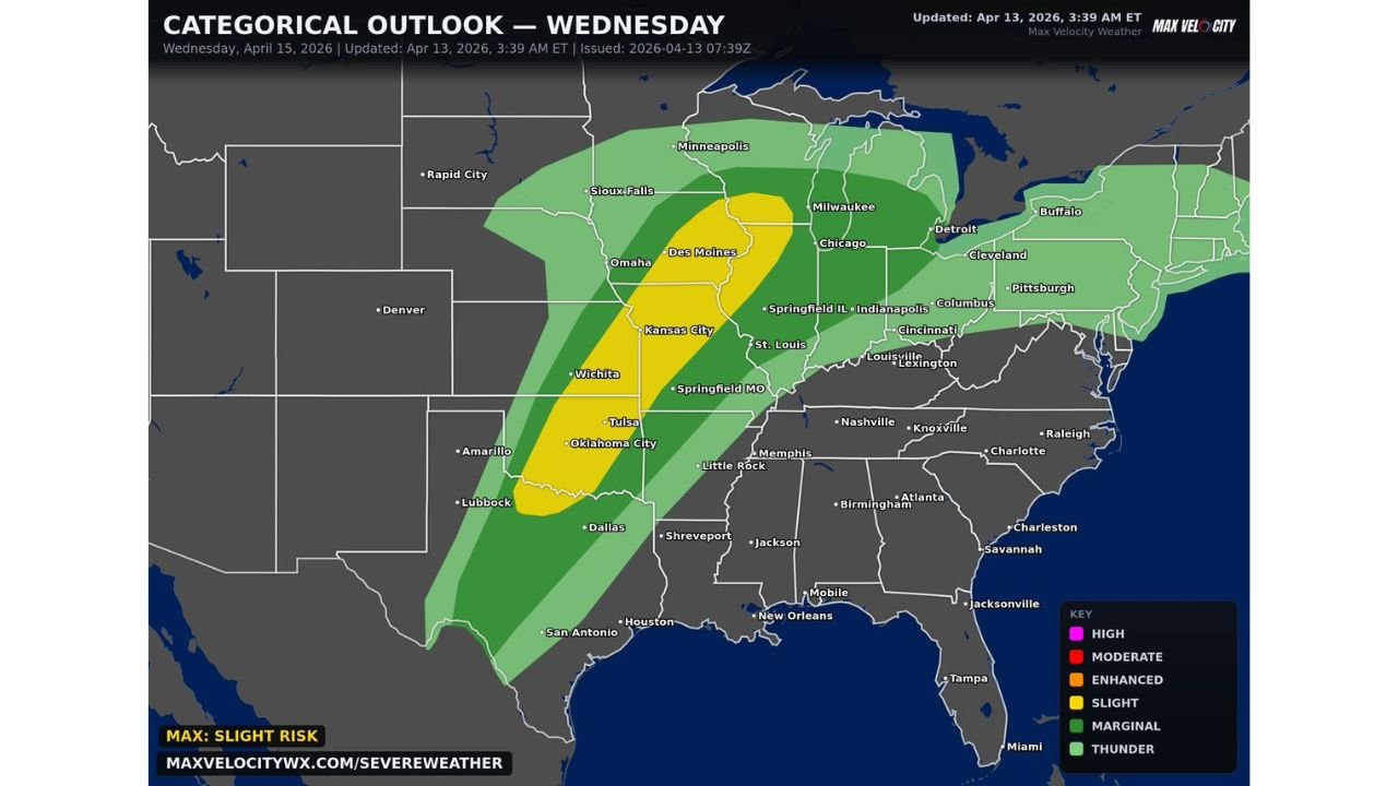
The categorical outlook for Wednesday April 15, 2026, updated at 3:39 AM ET on April 13, 2026 and issued at 07:39Z, places the maximum risk at a Slight Risk — Level 2 of 5 across the core of the severe weather corridor. The threat zone is well-defined and covers a long north-to-south axis through the heart of the central United States.
| Risk Level | Cities and Areas Covered |
|---|---|
| Slight Risk — Level 2/5 | Dallas, Wichita, Oklahoma City, Tulsa, Kansas City, Des Moines, Omaha, Springfield MO, Chicago, Milwaukee, Indianapolis, Springfield IL |
| Marginal Risk — Level 1/5 | San Antonio, Houston, Little Rock, Memphis, Nashville, Louisville, Lexington, Cincinnati, Columbus, Cleveland, Detroit, Pittsburgh, Sioux Falls, Minneapolis, Buffalo and surrounding areas |
| General Thunder | Broader surrounding areas including parts of the Southeast, Mid-Atlantic, and Northeast |
The Slight Risk zone runs in a defined diagonal band from northern Texas and Oklahoma north through Kansas, Missouri, Iowa, and Nebraska and into Illinois, Wisconsin, and the Chicago and Milwaukee corridor. The Marginal Risk zone fans widely on both sides, reaching from San Antonio and Houston in the south to Minneapolis, Buffalo, and Detroit in the north and east.
Primary Hazards for Wednesday
Wednesday’s severe weather setup carries two headline threats that forecasters are emphasizing clearly for the entire corridor:
- Damaging winds — the primary and most widespread hazard across the Slight and Marginal Risk zones on Wednesday, capable of downing trees and power lines across a large area
- Large hail — the second primary hazard, with any organized storm capable of producing hail that damages vehicles, roofs, and property across the threat corridor
Those two hazards alone make Wednesday a significant severe weather day. But there is a third and critical element that could make the situation considerably worse.
The Tornado Wild Card — Early Morning Convection Is the Key
Forecasters are raising a specific and important concern for Wednesday that adds another layer of danger to the outlook. Depending on how quickly convection can clear out in the early portion of the day, there may be an elevated tornado threat.
This is a setup-within-a-setup scenario. If overnight and early morning storms linger too long into Wednesday, they can disrupt the atmospheric boundary layer and reduce tornado potential for afternoon storms. But if that convection clears out efficiently and early enough — allowing the atmosphere to destabilize ahead of the main severe weather line — the environment could support an elevated tornado threat on top of the already significant wind and hail hazards.
This uncertainty is exactly why forecasters are urging people to stay tuned for updates as Wednesday approaches. The tornado threat component of Wednesday’s outlook could change significantly based on how the morning unfolds across the corridor.
Cities That Cannot Afford to Ignore Wednesday
The list of major cities sitting inside Wednesday’s Slight and Marginal Risk zones is extensive and spans multiple states:
Southern Plains: Dallas, Oklahoma City, Tulsa, Wichita, San Antonio, Houston
Central Plains and Midwest: Kansas City, Des Moines, Omaha, Springfield MO, Little Rock, Memphis
Great Lakes and Upper Midwest: Chicago, Milwaukee, Minneapolis, Sioux Falls, Detroit, Cleveland, Indianapolis, Columbus, Springfield IL
Ohio Valley and East: Louisville, Lexington, Cincinnati, Pittsburgh, Buffalo
Every city on that list needs to be monitoring Wednesday’s forecast actively and updating their severe weather plans as new information comes in over the next 48 hours.
Why Wednesday Is Different From Tuesday
Tuesday’s severe weather event focused heavily on supercell potential along the dryline with the primary concern being large hail and tornadoes from discrete storms. Wednesday shifts the emphasis somewhat — damaging winds become the headline hazard alongside large hail, and the tornado question becomes conditional on the morning convective evolution rather than a straightforward elevated risk.
That does not make Wednesday less dangerous — it makes it differently dangerous. A widespread damaging wind event across a corridor from Texas to the Great Lakes represents a threat that affects far more people than a localized supercell outbreak. Combined with large hail and the potential for an elevated tornado threat if conditions align correctly, Wednesday carries all the ingredients for a significant severe weather day.
What to Do Between Now and Wednesday
With forecasters explicitly asking people to spread the word and stay tuned for updates, preparation in the next 48 hours matters:
- Monitor forecast updates closely as Wednesday approaches — the tornado threat component especially could change based on how Tuesday evening and Wednesday morning evolve
- Have a severe weather plan in place for your home, workplace, and vehicle before Wednesday morning
- Check weather radio and app alert settings to ensure you will receive any warnings the moment they are issued for your county
- Be ready to act quickly on Wednesday — damaging wind events in particular can move fast and produce widespread damage with little warning time
- Spread the word to family, friends, and neighbors who may not be actively following the forecast, especially those in the Dallas, Oklahoma City, Kansas City, Chicago, and Milwaukee areas
Wednesday Severe Weather Summary
| Factor | Details |
|---|---|
| Valid date | Wednesday April 15, 2026 |
| Updated | April 13, 2026 at 3:39 AM ET |
| Maximum risk | Slight — Level 2 of 5 |
| Primary hazards | Damaging winds, large hail |
| Conditional hazard | Elevated tornado threat — dependent on morning convection clearing |
| Core Slight Risk cities | Dallas, Oklahoma City, Tulsa, Wichita, Kansas City, Des Moines, Omaha, Chicago, Milwaukee |
| Marginal Risk cities | Houston, San Antonio, Memphis, Louisville, Cincinnati, Detroit, Cleveland, Pittsburgh, Minneapolis, Buffalo |
| Key variable | How quickly early convection clears Wednesday morning |
Wednesday Is Round Two — And It Is Not a Smaller Threat
The severe weather outbreak does not end with Tuesday. Wednesday April 15 brings damaging winds, large hail, and a conditional tornado threat across the same broad corridor from Texas through the Plains and into the Great Lakes. The morning convection question adds a critical element of uncertainty that makes Wednesday’s final threat level a moving target right up until the storms arrive.
Stay informed, stay prepared, and spread the word. From Dallas and Oklahoma City in the south to Chicago, Milwaukee, and the Great Lakes in the north, Wednesday is shaping up as another dangerous day that demands respect and readiness across a massive stretch of the country.
Stay with CabarrusWeekly.com for live Wednesday severe weather updates, tornado watch and warning coverage, and storm reports across the full corridor from Texas through the Plains and into the Great Lakes.