Ada, Atoka and Durant to EF3 Tornado Risk as Supercells Fire at 4 PM Across South Central Oklahoma
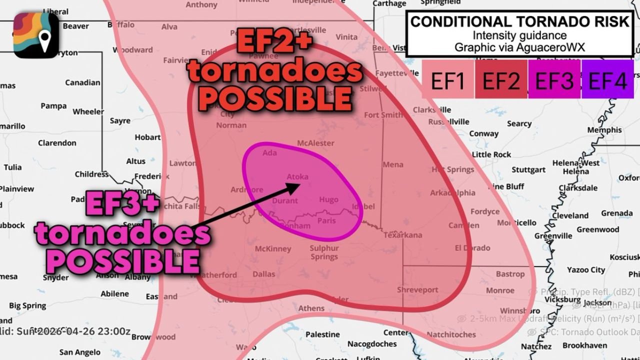
ADA, Oklahoma — The Storm Prediction Center has upgraded the tornado threat across south central and southeast Oklahoma, now explicitly indicating that tornadoes reaching EF3 strength are possible in a focused zone covering Ada, Atoka, Sulphur, Tishomingo, Madill, Colbert, Durant, Hugo, Antlers, and across the Red River into Paris, Texas. Rotating supercells are expected to fire in and near these communities around 4 PM Central time Saturday afternoon and will quickly become severe, producing large destructive hail and likely a few tornadoes.
The strongest supercells could produce softball-sized hail alongside the tornado threat, and an intense tornado or two reaching EF3 or beyond cannot be ruled out in the highlighted zone.
Two Separate Tornado Risk Zones — Very Different Threat Levels
The intensity guidance map draws a clear distinction between two zones that residents need to understand separately.
The larger pink zone covering most of central and eastern Oklahoma into northeast Texas carries an EF2 or greater tornado risk. This is the broader area where significant tornadoes are possible as supercells develop this afternoon. Oklahoma City, Norman, McAlester, Fort Smith, and communities across this wide area fall inside the EF2+ zone. Any tornado here has the potential to cause significant structural damage to well-built homes and is life-threatening to anyone not in a reinforced shelter.
Inside that larger zone sits a much smaller, more concentrated oval centered over Ada, Atoka, Durant, and Hugo where the intensity guidance reaches EF3 and EF4 territory. This is the specific corridor that the SPC is most carefully watching. An EF3 tornado produces winds between 136 and 165 mph, capable of destroying well-constructed homes, overturning trains, and stripping bark from trees. An EF4 crosses into catastrophic territory with winds above 166 mph.
The fact that the intensity guidance for this small oval extends to EF4 reflects how extreme the atmospheric parameters are in this particular corridor today.
Why 4 PM Is the Critical Hour
Supercell initiation timing around 4 PM Central puts storm development at the most dangerous intersection of the daily cycle. The afternoon heating maximum has been reached, loading the atmosphere with maximum surface instability from the day’s warmth. At the same time, the low-level jet is beginning its afternoon strengthening cycle, adding the low-level wind shear that drives near-surface rotation.
Storms that fire at this time have access to the full afternoon instability pool and immediately begin encountering the strengthening low-level jet. Supercells in this environment can become tornado-warned within 15 to 20 minutes of initial development. The lead time between a storm firing visually on radar and the first tornado warning in this environment is extremely short.
For communities like Ada, Durant, and Hugo — smaller cities without the large emergency management infrastructure of Oklahoma City — that short lead time makes having a personal shelter plan in place before 3 PM critical. Do not wait for the sirens. By the time sirens activate, the warning has already been issued and the tornado may be minutes away.
Softball Hail Alongside the Tornado Threat
The same supercells producing tornado potential today are also carrying the extreme hail threat that has been advertised all week. Softball-sized hail at 4 inches in diameter is forecast with the strongest storms across the EF3 zone. In a town the size of Ada or Antlers, a single supercell dropping softball hail can cause tens of millions of dollars in property damage across the community in a matter of minutes.
The hail and tornado threats are not sequential today — they can occur simultaneously from the same storm. A supercell producing softball hail overhead is also capable of spinning up a tornado on its southern flank at the same moment. This means seeking shelter from hail inside a vehicle is the worst possible decision this afternoon. Vehicle roofs offer no protection from softball hail and zero protection from a tornado.
The Narrow Window Before Storms Merge
Earlier analysis of today’s setup identified a key fail mode: storms eventually merging into a cluster that disrupts individual supercell rotation. That concern remains valid, but the SPC upgrade to EF3 potential reflects confidence that the discrete supercell phase, while it lasts, will produce a very dangerous tornado environment in the Ada to Hugo corridor.
The timeline is approximately 4 PM to 7 or 8 PM for the discrete supercell phase across southeast Oklahoma. After that, as storms merge, the tornado threat transitions toward a wind-dominant squall line threat. Every tornado that occurs today most likely occurs before sunset.
Communities in the EF3 Zone Need to Act Before 3 PM
Ada sits at the northern edge of the EF3 oval. Atoka is near the center. Durant and Hugo anchor the southern portion along the Red River. Antlers sits on the eastern edge. Paris, Texas is just across the state line and inside the high-end risk zone.
These are predominantly smaller communities, many with significant manufactured home populations that offer essentially no protection from EF2 or stronger tornadoes. Residents in manufactured homes across Pontotoc, Atoka, Bryan, Choctaw, and McCurtain counties in Oklahoma and Lamar County in Texas need to identify a permanent structure to shelter in before 4 PM and be inside it when storms arrive.
Do not attempt to outrun a tornado by vehicle in this terrain. Southeastern Oklahoma has numerous hills, curves, and limited road options that make vehicular escape from a moving tornado extremely dangerous.
CabarrusWeekly.com will provide continuous updates on Saturday afternoon’s tornado threat across southeast Oklahoma and north Texas as supercells develop starting at 4 PM.