Kentucky Derby Weekend Turns Frigid as 40-Degree Morning Lows Reach Georgia and NOAA Flags Illinois, Indiana and Ohio for Hazardous Cold May 2 Through 8
LOUISVILLE, Kentucky — The Kentucky Derby on May 3 is shaping up to be one of the coldest in recent memory. A big late-season cold air mass is pushing into the East next weekend and through the first days of May, dropping morning lows into the 40s as far south as Georgia at daybreak. For Louisville and Churchill Downs, this could be one of those Derby days where the fashion in the infield gets completely upstaged by the weather.
This may also be one of the last major cold fronts of the season across the East — but it is arriving with enough force that NOAA’s Climate Prediction Center has issued a formal hazardous temperature designation for Illinois, Indiana, Ohio, Michigan, Kentucky, and surrounding states from May 2 through 8.
What the Cold Actually Looks Like Across the Region
The NOAA 6-10 day temperature outlook valid April 30 through May 4 shows the highest-confidence cold anomaly centered over Illinois, Indiana, and Kentucky — a dark blue oval indicating 70 to 80% probability of below-normal temperatures across this zone. That is the highest confidence below-normal signal anywhere on the continental map for this period.
Moving outward from the core, Michigan and Ohio sit at 60 to 70% probability below normal. Wisconsin, Missouri, Tennessee, Virginia, and the Mid-Atlantic all show 50 to 60% probability of below-normal temperatures through the first days of May. The cold reaches as far south as Georgia and Alabama in the 33 to 50% probability range, which is the meteorological basis for the forecast of 40-degree morning lows reaching that far south.
Florida is the only area showing above-normal temperatures, holding onto Gulf warmth while everything to its north chills down.
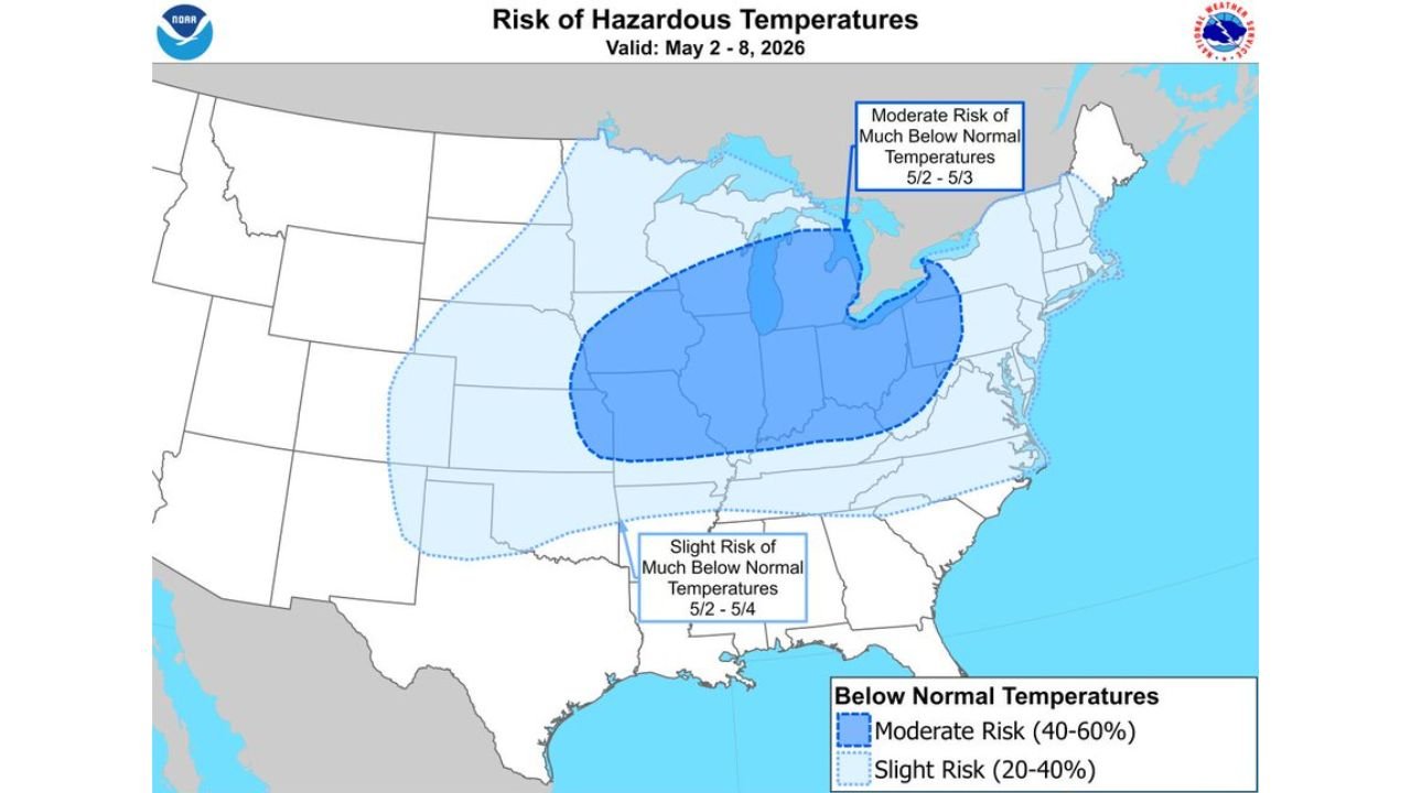
NOAA’s Hazardous Temperature Warning — May 2 Through 8
The Climate Prediction Center’s formal hazardous temperature product covers the same region in two tiers.
The Moderate Risk zone in darker blue — representing a 40 to 60% probability of much below normal temperatures — covers Michigan, Wisconsin, Illinois, Indiana, Ohio, Kentucky, West Virginia, Pennsylvania, and portions of New York and New Jersey. The most intense cold within this designation arrives May 2 through 3, which lands directly on Kentucky Derby weekend. This is not a brief overnight dip — it is a sustained cold pattern that holds through May 8 at minimum.
The Slight Risk dotted zone extends the hazardous cold threat further south through Tennessee, Arkansas, Mississippi, Alabama, and west across Kansas and Nebraska, covering the May 2 through 4 window as the cold air mass settles southward over several days.
The Kentucky Derby Connection
The Kentucky Derby runs on the first Saturday in May — May 3, 2026 — which lands squarely inside the most intense period of this cold pattern. Louisville sits inside the Moderate Risk zone where much below normal temperatures are forecast with 40 to 60% confidence. Morning lows at Churchill Downs could be in the 40s on Derby morning, with afternoon highs potentially struggling to reach the 60s depending on cloud cover and wind.
Derby fashion is built around sundresses and seersucker suits. A morning temperature in the 40s at the track changes that calculation entirely for the hundreds of thousands of people attending the race and surrounding events. For outdoor event planning across the Louisville metro and Kentucky generally, this cold snap deserves serious logistical attention.
The forecaster making this call specifically notes this could be one of the last big fronts of the season in the East. That framing matters — it suggests the pattern after this cold shot warms significantly, which would make surviving Derby weekend cold a one-time burden rather than the start of a prolonged cold spring.
Georgia at 40 Degrees Is the Headline Nobody Saw Coming
After a spring that has been running historically warm across much of the South and East, morning lows dropping into the 40s across Georgia at the start of May represents a dramatic reversal. Atlanta has been tracking well above normal through April. The jump from record April warmth to near-freezing morning lows within the span of two weeks is the kind of rapid pattern swing that characterizes the La Nina to El Nino transition period currently underway.
For Georgia gardeners who planted warm-season crops during the warm April stretch, morning lows in the 40s are not immediately lethal to most plants but do stress tropical and subtropical vegetables significantly. If overnight lows dip below 40°F in any clearing, sheltered areas — which is possible under clear skies with light winds — frost damage becomes a real concern even in Atlanta’s suburbs.
The Agricultural Stakes Across Kentucky, Indiana and Ohio
Kentucky tobacco transplants, early Indiana corn emergence, and Ohio fruit tree blossoms are all vulnerable during this window. The timing of the cold relative to crop development stage determines how much damage occurs. Fields planted during mid-April’s warmth are now several weeks into development and increasingly exposed to cold temperature stress.
Kentucky specifically faces dual exposure from both the Derby weekend cold and the broader agricultural threat to recently emerged crops across the Bluegrass and Pennyrile regions. Frost advisories and freeze warnings for Kentucky during the May 2-3 window are increasingly likely as the event approaches.
After May 8 — The Cold Breaks
The forecaster’s note that this may be one of the last big fronts of the season in the East is the silver lining in an otherwise rough forecast. Once this cold pattern releases its grip after May 8, the temperature pattern is expected to moderate and trend toward more seasonal or above-normal conditions across the East and South. The suffering is real but it appears to have an end date.
Get through Derby weekend cold. The other side of it looks considerably warmer.
CabarrusWeekly.com will continue tracking the Kentucky Derby weekend cold outbreak and provide frost and freeze advisory updates for Kentucky, Indiana, Ohio and Georgia as the event approaches.