Illinois and Missouri Face Three Rounds of Storms Monday April 27 With Damaging Wind Threat and Discrete Supercells Possible
ILLINOIS AND MISSOURI — A complicated and multi-round severe weather day is unfolding across Illinois and Missouri on Monday, April 27, 2026, with three distinct storm rounds expected to impact the region at different times and in different ways — some of which may overlap. Conditions will vary significantly from one part of the region to another throughout the day.
Round 1 — General Showers and Storms Now
As of 7:30 AM, Round 1 of general showers and storms is already moving through the region. This round is the most widespread and disorganized of the three, producing rainfall and lightning across a broad corridor from Missouri through central Illinois. This activity is not the primary severe weather concern for today but will play a critical role in how the atmosphere recovers ahead of the more dangerous rounds.
Round 2 — Damaging Wind Threat 11 AM to 1 PM
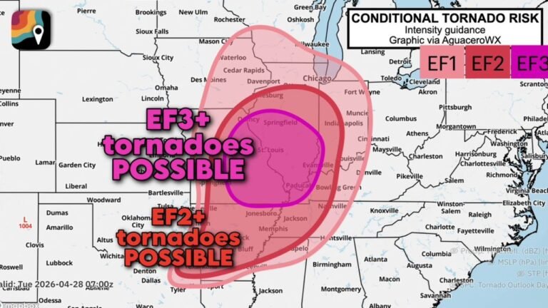
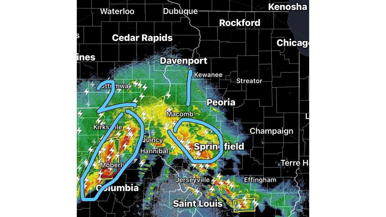
The second and more immediately dangerous round pushes into the region during the late morning hours between 11:00 AM and 1:00 PM. This round carries a damaging wind threat and is currently depicted on radar moving into the Quincy, Hannibal, Macomb, and Springfield corridor of western and central Illinois, along with portions of northeastern Missouri including Kirksville and Moberly.
Damaging wind gusts capable of downing trees and power lines are the primary concern with this round.
Round 3 — Discrete Supercells Into Southwestern Counties
A third round — not yet fully developed as of 7:30 AM — is forecast to bring a few discrete supercells into southwestern counties later in the day. This round is conditional on how well the atmosphere recovers from the morning storm activity. If sufficient instability can rebuild after Rounds 1 and 2 clear, these supercells could produce all severe hazards including tornadoes, large hail, and damaging winds.
If the atmosphere does not adequately recover, this round may be suppressed or significantly weakened.
Storm Round Summary
| Round | Timing | Primary Threat | Areas |
|---|---|---|---|
| Round 1 | Now — morning | General showers and storms | Broad Missouri and Illinois corridor |
| Round 2 | 11:00 AM to 1:00 PM | Damaging winds | Quincy, Hannibal, Springfield, Kirksville, Moberly |
| Round 3 | Afternoon — conditional | Discrete supercells, all hazards | Southwestern Illinois counties |
A Messy and Complicated Day
Forecasters are clear that today will be very different from one part of the region to another and at very different times. Some rounds may even overlap in certain areas, making storm timing difficult to pin down precisely. Residents across western and central Illinois and northeastern Missouri should remain weather aware throughout the entire day — not just during one specific window.
Stay weather aware, keep multiple warning sources active, and do not assume the threat has passed after any single round moves through. Stay with CabarrusWeekly.com for continuing live coverage throughout Monday’s storm event across Illinois and Missouri.