Tuesday Just Got Upgraded: Iowa, Illinois, and Wisconsin Now Face an Enhanced-Level Severe Weather Threat This Afternoon and Night With Large Hail and Tornadoes as the Highest Concern
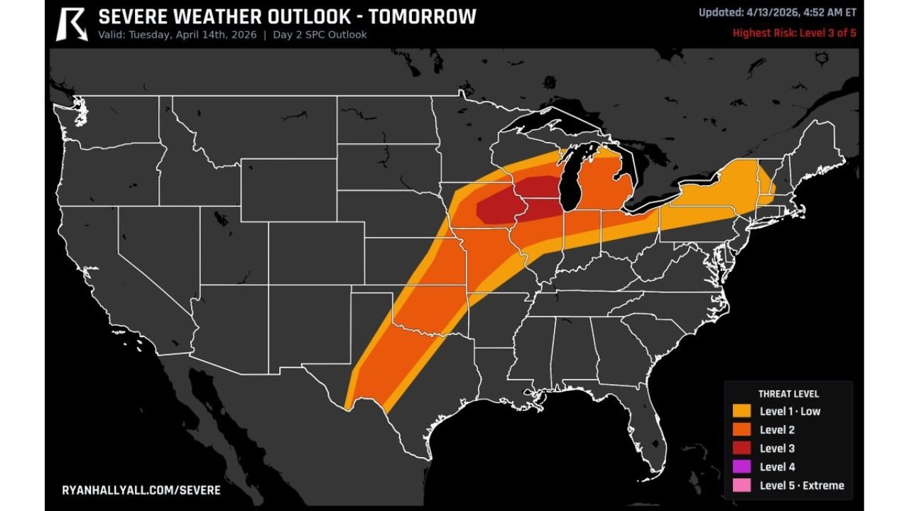
IOWA, ILLINOIS, AND WISCONSIN — Tuesday’s severe weather threat has been upgraded and the stakes just got significantly higher. The SPC Day 2 outlook for Tuesday April 14, 2026, updated at 4:52 AM ET on April 13, 2026, now places the highest risk at Level 3 of 5 — an Enhanced Risk — directly over Iowa, Illinois, and Wisconsin. Severe storms are likely Tuesday afternoon and into the night, with large hail and tornadoes identified as the highest concerns for the core of the threat zone.
This Is No Longer a Slight Risk Event — It Has Been Upgraded
What was previously being discussed as a Slight Risk event for Tuesday has been elevated. The SPC Day 2 outlook now shows a defined Enhanced Risk — Level 3 of 5 sitting over the heart of the Upper Midwest, making Tuesday a significantly more dangerous severe weather day than earlier forecasts suggested. This upgrade reflects increasing confidence in the atmosphere’s ability to support organized, long-track severe storms across Iowa, Illinois, and Wisconsin Tuesday afternoon and night.
Risk Zones for Tuesday April 14
| Risk Level | Areas Covered |
|---|---|
| Enhanced Risk — Level 3/5 | Iowa, Illinois, Wisconsin — the core highest threat zone |
| Level 2 Risk | Surrounding corridor from the southern Plains northeast through the Ohio Valley and into Michigan and the Northeast |
| Level 1 Risk | Broader outer zone covering the Gulf Coast states, mid-Atlantic, and New England |
The Enhanced Risk Level 3 zone is tightly defined and centered squarely over Iowa, Illinois, and Wisconsin — the bullseye of Tuesday’s most dangerous conditions. Surrounding that core, the Level 2 zone stretches broadly from the southern Plains northeast through Indiana, Ohio, Michigan, Pennsylvania, and into New York and New England. The Level 1 outer zone fans even further, covering portions of the Gulf Coast states and reaching into the mid-Atlantic.
The Highest Concern: Large Hail and Tornadoes
For residents sitting inside the Enhanced Risk zone across Iowa, Illinois, and Wisconsin, forecasters are identifying two specific hazards as the primary and most serious threats Tuesday afternoon and night:
- Large hail — a high-confidence threat for the Enhanced Risk zone, with the potential for significant and damaging hail sizes from organized supercell storms
- Tornadoes — elevated tornado concern for Iowa, Illinois, and Wisconsin, particularly during the afternoon and evening hours when instability peaks and wind shear values are highest
The combination of large hail and tornado potential inside an Enhanced Risk — Level 3 zone is a setup that demands serious preparation and active weather awareness throughout Tuesday afternoon and well into Tuesday night.
Tuesday Afternoon and Night — The Critical Window
Severe storms are expected to develop Tuesday afternoon and the threat is explicitly noted to continue into the night. This is a critical detail. Nighttime severe weather — particularly tornadoes — is significantly more dangerous because:
- Visibility is essentially zero in the path of a nighttime tornado
- Many residents are asleep and may not hear outdoor warning sirens
- The instinctive visual cues that daytime severe weather provides are absent entirely
The fact that this Enhanced Risk event extends into Tuesday night for Iowa, Illinois, and Wisconsin means that residents cannot simply plan to be weather-aware during daylight hours and assume the threat passes by evening. The most dangerous portion of the event could arrive after dark.
The Upgraded Threat Demands Upgraded Preparation
The jump from a Slight Risk to an Enhanced Risk — Level 3 is a significant escalation that requires a matching escalation in preparation. Level 3 events produce widespread and damaging severe weather across the threat zone and represent a day when the atmosphere is genuinely loaded and capable of producing long-track, organized severe storm activity.
For residents across Iowa, Illinois, and Wisconsin specifically:
- Identify your tornado shelter right now — a basement or interior room on the lowest floor away from windows — before Tuesday afternoon arrives
- Charge all devices and have backup power ready in case severe storms knock out power Tuesday night
- Set multiple weather alerts on your phone and ensure they are enabled for nighttime hours — do not put your phone on silent Tuesday night
- Have a weather radio with battery backup turned on and programmed for your county so alerts wake you if a warning is issued while you sleep
- Know the difference between a watch and a warning — a watch means conditions are favorable for severe weather, a warning means a severe storm or tornado is imminent or occurring
- Talk to your family today about what to do if a tornado warning is issued Tuesday night while everyone is asleep
Tuesday Severe Weather Outlook — Full Summary
| Factor | Details |
|---|---|
| Valid date | Tuesday April 14, 2026 |
| Updated | April 13, 2026 at 4:52 AM ET |
| Highest risk level | Enhanced — Level 3 of 5 |
| Enhanced Risk states | Iowa, Illinois, Wisconsin |
| Primary hazards | Large hail, tornadoes |
| Timing | Tuesday afternoon through Tuesday night |
| Level 2 zone | Southern Plains northeast through Ohio Valley, Michigan, New York |
| Level 1 zone | Gulf Coast states, mid-Atlantic, New England |
| Key overnight concern | Nighttime tornado potential while residents are asleep |
Iowa, Illinois, and Wisconsin Are in the Bullseye — Take Tuesday Seriously
The upgrade to Enhanced Risk — Level 3 of 5 for Iowa, Illinois, and Wisconsin is the clearest signal yet that Tuesday April 14 is shaping up as a genuinely dangerous and potentially historic severe weather day for the Upper Midwest. Large hail and tornadoes are the highest concerns, and the threat extends well into Tuesday night — meaning this is not an event that ends at sunset.
If you live in Iowa, Illinois, or Wisconsin, Tuesday is a day to treat with the same seriousness you would give any major severe weather event. The atmosphere is loaded, the models are in agreement, and the forecasters have upgraded the risk. Now it is time to prepare accordingly.
Stay with CabarrusWeekly.com for live Tuesday severe weather coverage, tornado warnings and storm reports across Iowa, Illinois, Wisconsin, and the full Enhanced Risk corridor as the event unfolds Tuesday afternoon and into the night.