This Mother’s Day Evening, Palm Coast, Daytona Beach, Orlando, Titusville, and Cocoa Beach Face Large Hail, Damaging Winds, and a Funnel Cloud Threat as Severe Storms Push Ashore After 5:30 PM
CENTRAL FLORIDA — A line of potentially severe thunderstorms is set to push through the I-95 corridor of central Florida on the evening of Sunday, May 10, threatening outdoor Mother’s Day plans from Palm Coast south through Daytona Beach, Orlando, Titusville, and down to Cocoa Beach.
Storms Building Along the Coast by Late Afternoon
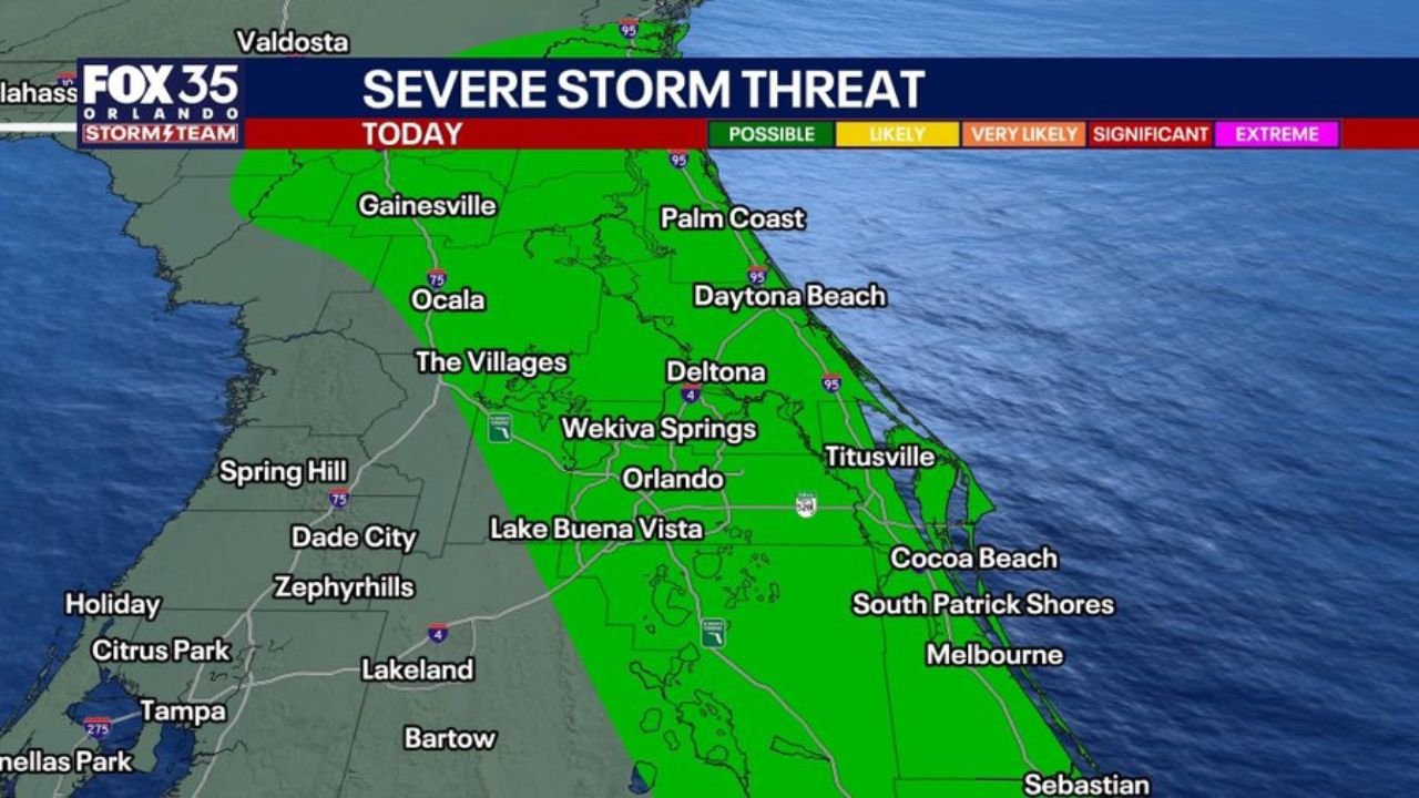
The severe storm threat today is rated Possible, but that does not mean these storms will be weak. The threat zone covers a wide swath of central Florida’s east side, stretching from Gainesville and Ocala in the north down through Orlando, Lake Buena Vista, and into the Sebastian area to the south.
The I-95 corridor communities face the greatest exposure, as storm cells are expected to ride the coastline and interact with the late-day sea breeze.
When the Storms Are Expected to Hit
Forecast model data shows the first significant storm cells developing by 5:30 PM near Palm Coast and Daytona Beach. By 7:00 PM, the activity shifts and intensifies closer to Titusville and the Cocoa Beach area, with storm cores moving east toward the Atlantic.
- Earliest arrival: 5:30 PM — Palm Coast, Daytona Beach
- Peak window: 7:00 PM — Titusville, Cocoa Beach, Orlando metro east
- Areas most exposed: I-95 corridor from Palm Coast to Cocoa Beach
Hazards to Watch For
One or two storms within the line could be Severe Warned, meaning they meet the threshold for dangerous conditions. The primary threats include:
- Large hail
- Damaging winds
- Funnel cloud possible — particularly in beach towns where storms interact with the late-day Seabreeze
What This Means for Mother’s Day Evening
If you have outdoor plans anywhere along the I-95 corridor — from Palm Coast through Daytona down to Cocoa Beach — be ready to move indoors quickly. The storm window is concentrated in the 5:30 PM to 7:00 PM period, but activity could linger into the evening.
Inland areas west of I-95, including Ocala, The Villages, and Lakeland, face less direct exposure but remain in the broader threat zone.
The Bigger Picture
This setup mirrors conditions seen the previous Friday evening, with storms capable of rapid intensification as they collide with the coastal Seabreeze. The threat is real but confined largely to the eastern corridor — inland communities face lower risk tonight.
Stay with CabarrusWeekly.com for the latest updates as these storms develop through Mother’s Day evening.