Caribbean and Gulf Coast Face Very Wet Pattern Late May Into June With Low Wind Shear Opening Door for Possible Weak Cyclone Activity
CARIBBEAN AND GULF COAST — Climate model guidance is consistently signaling a very wet Caribbean at the end of May into early June 2026, with accumulated precipitation anomalies running well above normal across the Caribbean basin, Gulf of Mexico and Gulf Coast states during the May 26 through June 2 window. Dropping wind shear during this same timeframe is raising the possibility of organized convection or weak cyclone activity becoming sustainable across the region.
Precipitation Anomalies Running Well Above Normal Late May Into June
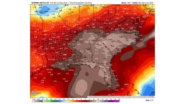
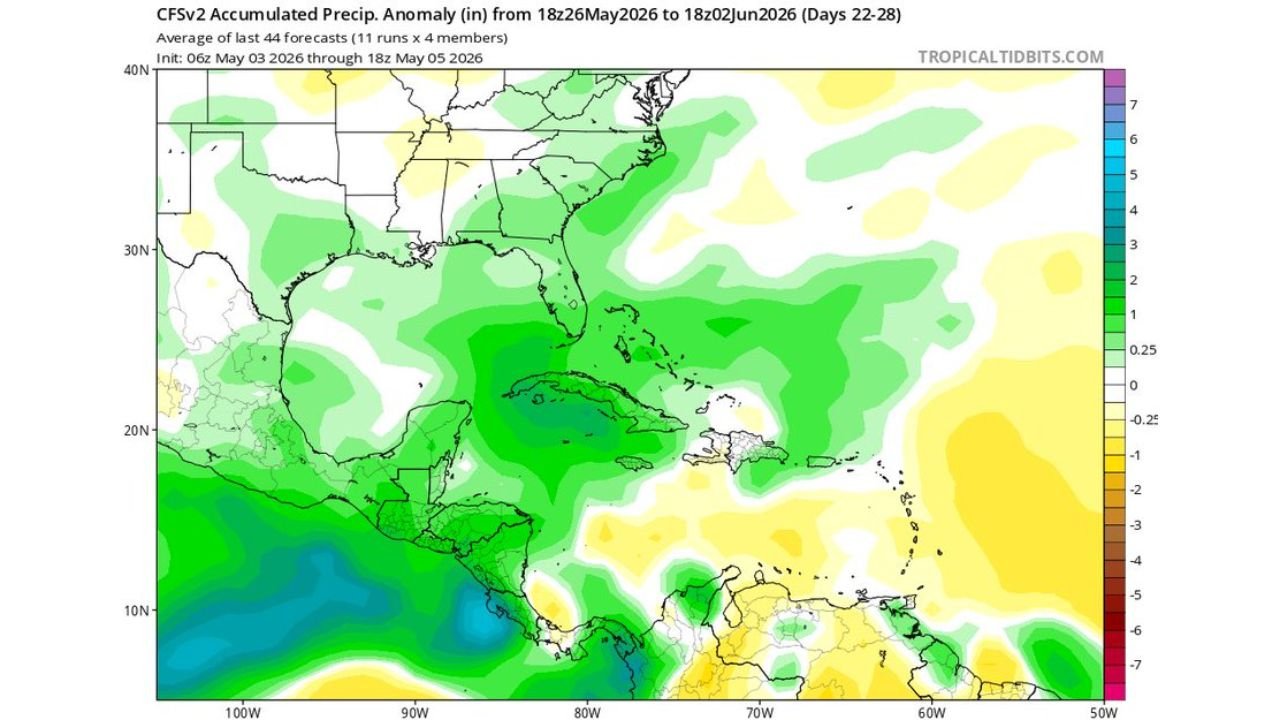
The accumulated precipitation anomaly forecast valid May 26 through June 2, 2026 shows a broad swath of above normal rainfall — indicated by green shading — covering:
- Gulf of Mexico and northern Gulf Coast
- Cuba, the Bahamas and the western Caribbean
- Florida and the Southeast US coast
- Central America and southern Mexico
The anomaly signal across the Caribbean core and Gulf Coast is among the strongest on the map, with values running 1 to 3 inches above normal across a wide zone during this one-week period.
Wind Shear Drops Off — A Key Ingredient for Tropical Development
The bulk shear anomaly map valid for the same May 26 through June 2 period shows below normal wind shear — indicated by red and orange shading — developing across the Caribbean, Lesser Antilles and the tropical Atlantic. Low-level shear dropping off in the Caribbean basin during this timeframe leaves a generally favorable environment for any organized convection that develops.
This combination of above normal moisture and reduced wind shear is what makes the late May into early June window worth monitoring for potential tropical activity.
Tropical Development Possible but Not Certain
The guidance raises the possibility that organized convection or a weak cyclone could become sustainable across the Caribbean during this timeframe. This remains a possibility rather than a confirmed forecast, as the environment would need to come together in a precise way to support actual tropical development.
| Signal | Status for Late May Into June |
|---|---|
| Precipitation anomaly | Well above normal across Caribbean and Gulf Coast |
| Low level wind shear | Dropping off, below normal anomaly |
| Tropical development | Organized convection or weak cyclone possible |
| Confidence | Possible, not confirmed |
Stay with CabarrusWeekly.com for continuing updates on the late May tropical weather outlook across the Caribbean and Gulf Coast.